|
|
|
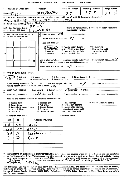
Specific Water Well Detail |
|
|
| Location Info | |||
| Owner: Huber, Spike | Status: Plugged | ||
| Location: T15S, R21W, Sec. 25, SE SE SE | County: Trego | ||
| Directions: from Brownell: 4 mi N on 147, 1 mi E, 1.25 mi W | |||
| Latitude: 38.7118861 | Longitude: -99.5989377 | Datum NAD 27 | |
| Latitude: 38.7118992 | Longitude: -99.5993288 | Datum NAD 83 | |
| Longitude and latitude calculated by Survey from township-range-section-quarter calls. Only good to within the quarter call accuracy. | |||
| View well on interactive map | |||
| General Info | ||
| Well Depth: 88 ft. | Elevation: ft. | |
| Static Water Level: 27 ft. | Est. Yield: gpm. | |
| Comp. Date: 06-Mar-2002 | Well Use: Domestic | |
| DWR Applic. #: | Other ID: | |
| Driller Info | ||
| Driller: Town & Country Water Well Service | License #: 626 | |
| Scanned Form | View scan |
| Casing Info | ||
|
Casing Type:
Diam: in. Casing height above land surface: in | ||
| Grout Info | ||
| Grout used: | From: to ft | |
| Source of Possible Contamination | ||
| Source: | ||
| Direction from well: | Distance: ft | |