|
|
|
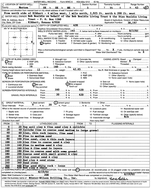
Specific Water Well Detail |
|
|
| Location Info | |||
| Owner: Boaldin, Bob | Status: Constructed | ||
| Location: T35S, R43W, Sec. 3, SE SE NE | County: Morton | ||
| Directions: from N side of Elkhart: 4 mi W, 1 mi N, 2925 feet N, 200 feet W | |||
| Latitude: 37.0331247 | Longitude: -101.9722235 | Datum NAD 27 | |
| Latitude: 37.0331473 | Longitude: -101.9726708 | Datum NAD 83 | |
| Longitude and latitude calculated by Survey from township-range-section-quarter calls. Only good to within the quarter call accuracy. | |||
| View well on interactive map | |||
| General Info | ||
| Well Depth: 420 ft. | Elevation: ft. | |
| Static Water Level: 145 ft. | Est. Yield: gpm. | |
| Comp. Date: 19-Aug-2002 | Well Use: Irrigation | |
| DWR Applic. #: 38197 | Other ID: | |
| Links | |
| No Wizard information available. | |
| View info from WIMAS Water Right Data base... | |
| Driller Info | ||
| Driller: Minter-Wilson Drlg. Co., Inc. | License #: 208 | |
| Scanned Form | View scan |
|
Chemical Sample Submitted?:
Water Well disinfected?: | ||
| Casing Info | ||
| Casing Type:
Casing Joints: |
Diam: in. to ft | |
| Casing height above land surface: in
Casing Weight: lbs/ft Wall thickness or gauge no.: | ||
| Screen and Perforation Info | ||
| Screen Type: | Screen Openings: | |
| Screen-perforated intervals | From: ft to ft | |
| Gravel pack intervals | From: ft to ft | |
| Grout Info | ||
| Grout used: | From: to ft | |
| Source of Possible Contamination | ||
| Source: | ||
| Direction from well: | Distance: ft | |
| Lithologic Log
(Log data entered by KGS.) | ||
| From: 0 ft. to 20 ft. | top soil clay and fine sand clay and caliche | |
| From: 20 ft. to 40 ft. | caliche fine to coarse sand medium to large gravel | |
| From: 40 ft. to 60 ft. | clay, thin rock layers, fine sand | |
| From: 60 ft. to 80 ft. | fine to medium sand | |
| From: 80 ft. to 100 ft. | fine sand, clay and thin rock layers | |
| From: 100 ft. to 120 ft. | clay fine to coarse sand and clay | |
| From: 120 ft. to 140 ft. | fine to medium sand and clay | |
| From: 140 ft. to 160 ft. | clay and fine sand in layers | |
| From: 160 ft. to 180 ft. | fine to coarse sand with some gravel | |
| From: 180 ft. to 200 ft. | coarse sand with small gravel and clay | |
| From: 200 ft. to 220 ft. | clay coarse sand and clay | |
| From: 220 ft. to 240 ft. | red clay and sandstone | |
| From: 240 ft. to 360 ft. | sandstone | |
| From: 360 ft. to 400 ft. | fine sand white rock- loose | |
| From: 400 ft. to 420 ft. | red clay and shale | |