|
|
|
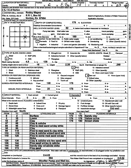
Specific Water Well Detail |
|
|
| Location Info | |||
| Owner: Mapes, Robby | Status: Constructed | ||
| Location: T2S, R23W, Sec. 14, C E2 | County: Norton | ||
| Directions: from Norton: 3 mi N, 1 mi E | |||
| Latitude: 39.8782921 | Longitude: -99.8741665 | Datum NAD 27 | |
| Latitude: 39.8782982 | Longitude: -99.8745659 | Datum NAD 83 | |
| Longitude and latitude calculated by Survey from township-range-section-quarter calls. Only good to within the quarter call accuracy. | |||
| View well on interactive map | |||
| General Info | ||
| Well Depth: 178 ft. | Elevation: ft. | |
| Static Water Level: 82 ft. | Est. Yield: gpm. | |
| Comp. Date: 04-Feb-2002 | Well Use: Domestic | |
| DWR Applic. #: | Other ID: | |
| Driller Info | ||
| Driller: Jay C. Woofter Pump & Well, Inc. | License #: 554 | |
| Scanned Form | View scan |
|
Chemical Sample Submitted?:
Water Well disinfected?: | ||
| Casing Info | ||
| Casing Type:
Casing Joints: |
Diam: in. to ft | |
| Casing height above land surface: in
Casing Weight: lbs/ft Wall thickness or gauge no.: | ||
| Screen and Perforation Info | ||
| Screen Type: | Screen Openings: | |
| Screen-perforated intervals | From: ft to ft | |
| Gravel pack intervals | From: ft to ft | |
| Grout Info | ||
| Grout used: | From: to ft | |
| Source of Possible Contamination | ||
| Source: | ||
| Direction from well: | Distance: ft | |
| Lithologic Log
(Log data entered by KGS.) | ||
| From: 0 ft. to 2 ft. | surface | |
| From: 2 ft. to 15 ft. | loess | |
| From: 15 ft. to 37 ft. | clay | |
| From: 37 ft. to 88 ft. | clay and caliche | |
| From: 88 ft. to 95 ft. | fine to medium sand with clay streak | |
| From: 95 ft. to 99 ft. | clay | |
| From: 99 ft. to 110 ft. | fine to medium sand and clay streaks | |
| From: 110 ft. to 119 ft. | clay and caliche with medium sand streaks | |
| From: 119 ft. to 126 ft. | fine to some medium sand with clay streaks | |
| From: 126 ft. to 136 ft. | clay and caliche with a few sand streaks | |
| From: 136 ft. to 144 ft. | fine sand with clay and caliche | |
| From: 144 ft. to 165 ft. | sandy clay with caliche streaks | |
| From: 165 ft. to 172 ft. | fine sand | |
| From: 172 ft. to 176 ft. | sandy clay | |
| From: 176 ft. to 178 ft. | yellow ochre | |
| From: 178 ft. to 180 ft. | brown shale | |