|
|
|
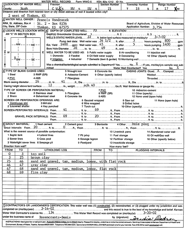
Specific Water Well Detail |
|
|
| Location Info | |||
| Owner: Vondracek, Francis | Status: Constructed | ||
| Location: T18S, R17W, Sec. 21, W2 NW SW | County: Rush | ||
| Directions: from Timken: 2 mi W | |||
| Latitude: 38.4703367 | Longitude: -99.215185 | Datum NAD 27 | |
| Latitude: 38.4703498 | Longitude: -99.2155644 | Datum NAD 83 | |
| Longitude and latitude calculated by Survey from township-range-section-quarter calls. Only good to within the quarter call accuracy. | |||
| View well on interactive map | |||
| General Info | ||
| Well Depth: 70 ft. | Elevation: ft. | |
| Static Water Level: 22 ft. | Est. Yield: 1400 gpm. | |
| Comp. Date: 14-Mar-2002 | Well Use: Irrigation | |
| DWR Applic. #: 3754 | Other ID: | |
| Links | |
| View info from Wizard Water Level Data base... | |
| View info from WIMAS Water Right Data base... | |
| Driller Info | ||
| Driller: Rosencrantz-Bemis Enterprises, Inc. | License #: 134 | |
| Scanned Form | View scan |
|
Chemical Sample Submitted?:
Water Well disinfected?: | ||
| Casing Info | ||
| Casing Type:
Casing Joints: |
Diam: in. to ft | |
| Casing height above land surface: in
Casing Weight: lbs/ft Wall thickness or gauge no.: | ||
| Screen and Perforation Info | ||
| Screen Type: | Screen Openings: | |
| Screen-perforated intervals | From: ft to ft | |
| Gravel pack intervals | From: ft to ft | |
| Grout Info | ||
| Grout used: | From: to ft | |
| Source of Possible Contamination | ||
| Source: | ||
| Direction from well: | Distance: ft | |
| Lithologic Log
(Log data entered by KGS.) | ||
| From: 0 ft. to 3 ft. | topsoil | |
| From: 3 ft. to 25 ft. | brown clay | |
| From: 25 ft. to 46 ft. | sand and gravel, tan, medium, loose, with flat rock | |
| From: 46 ft. to 47 ft. | gray clay | |
| From: 47 ft. to 68 ft. | sand and gravel, tan, medium, loose, flat rock | |
| From: 68 ft. to 69 ft. | fire clay | |