|
|
|
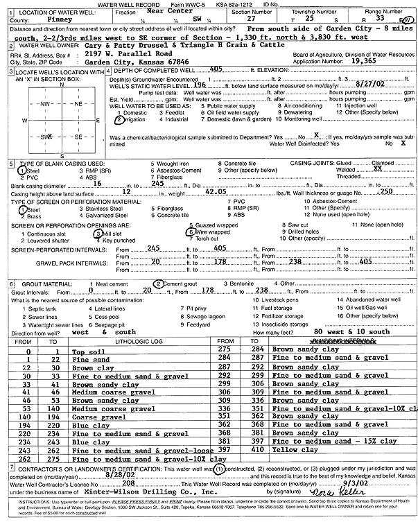
Specific Water Well Detail |
|
|
| Location Info | |||
| Owner: Drussel, Gary and Patty | Status: Constructed | ||
| Location: T25S, R33W, Sec. 27, C SW | County: Finney | ||
| Directions: from S side of Garden City: 8 mi S, 2.7 mi W to SE corner, 1330 feet N, and 3830 feet W | |||
| Latitude: 37.847784 | Longitude: -100.9333514 | Datum NAD 27 | |
| Latitude: 37.8478077 | Longitude: -100.9337946 | Datum NAD 83 | |
| Longitude and latitude calculated by Survey from township-range-section-quarter calls. Only good to within the quarter call accuracy. | |||
| View well on interactive map | |||
| General Info | ||
| Well Depth: 405 ft. | Elevation: ft. | |
| Static Water Level: 196 ft. | Est. Yield: gpm. | |
| Comp. Date: 28-Aug-2002 | Well Use: Irrigation | |
| DWR Applic. #: 19365 | Other ID: | |
| Links | |
| No Wizard information available. | |
| View info from WIMAS Water Right Data base... | |
| Driller Info | ||
| Driller: Minter-Wilson Drlg. Co., Inc. | License #: 208 | |
| Scanned Form | View scan |
|
Chemical Sample Submitted?:
Water Well disinfected?: | ||
| Casing Info | ||
| Casing Type:
Casing Joints: |
Diam: in. to ft | |
| Casing height above land surface: in
Casing Weight: lbs/ft Wall thickness or gauge no.: | ||
| Screen and Perforation Info | ||
| Screen Type: | Screen Openings: | |
| Screen-perforated intervals | From: ft to ft | |
| Gravel pack intervals | From: ft to ft | |
| Grout Info | ||
| Grout used: | From: to ft | |
| Source of Possible Contamination | ||
| Source: | ||
| Direction from well: | Distance: ft | |
| Lithologic Log
(Log data entered by KGS.) | ||
| From: 0 ft. to 1 ft. | top soil | |
| From: 1 ft. to 22 ft. | fine sand | |
| From: 22 ft. to 30 ft. | brown clay | |
| From: 30 ft. to 33 ft. | fine to medium sand and gravel | |
| From: 33 ft. to 41 ft. | brown sandy clay | |
| From: 41 ft. to 46 ft. | medium coarse gravel | |
| From: 46 ft. to 53 ft. | brown sandy clay | |
| From: 53 ft. to 140 ft. | medium coarse gravel | |
| From: 140 ft. to 194 ft. | coarse gravel | |
| From: 194 ft. to 220 ft. | blue clay | |
| From: 220 ft. to 234 ft. | fine to medium sand and gravel | |
| From: 234 ft. to 243 ft. | blue clay | |
| From: 243 ft. to 262 ft. | fine to medium sand and gravel - loose | |
| From: 262 ft. to 275 ft. | fine to medium sand and gravel - 10% clay | |
| From: 275 ft. to 284 ft. | brown sandy clay | |
| From: 284 ft. to 287 ft. | fine to medium sand and gravel | |
| From: 287 ft. to 292 ft. | brown sandy clay | |
| From: 292 ft. to 299 ft. | fine to medium sand and gravel | |
| From: 299 ft. to 306 ft. | brown sandy clay | |
| From: 306 ft. to 309 ft. | fine to medium sand and gravel | |
| From: 309 ft. to 336 ft. | brown sandy clay | |
| From: 336 ft. to 351 ft. | fine to medium sand and gravel - 10% clay | |
| From: 351 ft. to 362 ft. | brown sandy clay | |
| From: 362 ft. to 368 ft. | fine to medium sand and gravel | |
| From: 368 ft. to 381 ft. | brown sandy clay | |
| From: 381 ft. to 397 ft. | fine to medium sand - 15% clay | |
| From: 397 ft. to 410 ft. | yellow clay | |