|
|
|
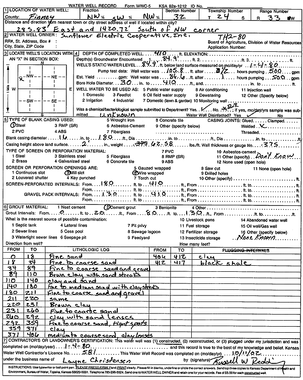
Specific Water Well Detail |
|
|
| Location Info | |||
| Owner: Sunflower Electric Power Corp. | Status: Constructed | ||
| Location: T24S, R33W, Sec. 32, NW SW NW | County: Finney | ||
| Directions: 285.83' E, 1420.72' S of NW corner (TH2-80) | |||
| Latitude: 37.9268118 | Longitude: -100.9733823 | Datum NAD 27 | |
| Latitude: 37.9268357 | Longitude: -100.9738263 | Datum NAD 83 | |
| Longitude and latitude calculated by Survey from township-range-section-quarter calls. Only good to within the quarter call accuracy. | |||
| View well on interactive map | |||
| General Info | ||
| Well Depth: 410 ft. | Elevation: ft. | |
| Static Water Level: 84.9 ft. | Est. Yield: gpm. | |
| Comp. Date: 04-Jan-1980 | Well Use: (unstated)/abandoned | |
| DWR Applic. #: | Other ID: | |
| Links | |
| No Wizard information available. | |
| View info from WIMAS Water Right Data base... | |
| Driller Info | ||
| Driller: Layne Western | License #: 581 | |
| Scanned Form | View scan |
|
Chemical Sample Submitted?:
Water Well disinfected?: | ||
| Casing Info | ||
| Casing Type:
Casing Joints: |
Diam: in. to ft | |
| Casing height above land surface: in
Casing Weight: lbs/ft Wall thickness or gauge no.: | ||
| Screen and Perforation Info | ||
| Screen Type: | Screen Openings: | |
| Screen-perforated intervals | From: ft to ft | |
| Gravel pack intervals | From: ft to ft | |
| Grout Info | ||
| Grout used: | From: to ft | |
| Source of Possible Contamination | ||
| Source: | ||
| Direction from well: | Distance: ft | |
| Lithologic Log
(Log data entered by KGS.) | ||
| From: 0 ft. to 18 ft. | fine sand | |
| From: 18 ft. to 34 ft. | fine to coarse sand | |
| From: 34 ft. to 89 ft. | fine to coarse sand and gravel | |
| From: 89 ft. to 110 ft. | brown clay with sand streaks | |
| From: 110 ft. to 140 ft. | clay and sand | |
| From: 140 ft. to 180 ft. | fine to medium sand with clay streaks | |
| From: 180 ft. to 211 ft. | fine to coarse sand and gravel | |
| From: 211 ft. to 220 ft. | fine to coarse sand and gravel | |
| From: 220 ft. to 231 ft. | brown clay | |
| From: 231 ft. to 260 ft. | fine to coarse sand | |
| From: 260 ft. to 292 ft. | clay with sand lenses | |
| From: 292 ft. to 359 ft. | fine to coarse sand, tight spots | |
| From: 359 ft. to 371 ft. | clay | |
| From: 371 ft. to 406 ft. | medium to coarse sand, clay lenses | |
| From: 406 ft. to 412 ft. | clay | |
| From: 412 ft. to 417 ft. | black shale | |