|
|
|
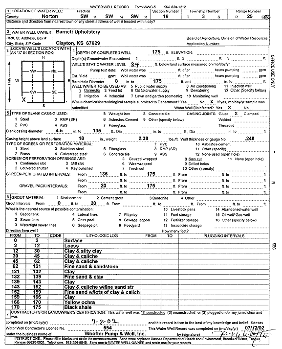
Specific Water Well Detail |
|
|
| Location Info | |||
| Owner: Barnett Upholstery | Status: Constructed | ||
| Location: T3S, R25W, Sec. 18, SW SW SW | County: Norton | ||
| Directions: | |||
| Latitude: 39.7848848 | Longitude: -100.1790918 | Datum NAD 27 | |
| Latitude: 39.7848896 | Longitude: -100.1795052 | Datum NAD 83 | |
| Longitude and latitude calculated by Survey from township-range-section-quarter calls. Only good to within the quarter call accuracy. | |||
| View well on interactive map | |||
| General Info | ||
| Well Depth: 175 ft. | Elevation: ft. | |
| Static Water Level: 84 ft. | Est. Yield: gpm. | |
| Comp. Date: 08-Jul-2002 | Well Use: Domestic | |
| DWR Applic. #: | Other ID: | |
| Driller Info | ||
| Driller: Jay C. Woofter Pump & Well, Inc. | License #: 554 | |
| Scanned Form | View scan |
|
Chemical Sample Submitted?:
Water Well disinfected?: | ||
| Casing Info | ||
| Casing Type:
Casing Joints: |
Diam: in. to ft | |
| Casing height above land surface: in
Casing Weight: lbs/ft Wall thickness or gauge no.: | ||
| Screen and Perforation Info | ||
| Screen Type: | Screen Openings: | |
| Screen-perforated intervals | From: ft to ft | |
| Gravel pack intervals | From: ft to ft | |
| Grout Info | ||
| Grout used: | From: to ft | |
| Source of Possible Contamination | ||
| Source: | ||
| Direction from well: | Distance: ft | |
| Lithologic Log
(Log data entered by KGS.) | ||
| From: 0 ft. to 2 ft. | surface | |
| From: 2 ft. to 12 ft. | loess | |
| From: 12 ft. to 30 ft. | clay and silty clay | |
| From: 30 ft. to 45 ft. | clay and caliche | |
| From: 45 ft. to 62 ft. | clay and caliche | |
| From: 62 ft. to 121 ft. | fine sand and sandstone | |
| From: 121 ft. to 132 ft. | clay | |
| From: 132 ft. to 139 ft. | fine sand and clay | |
| From: 139 ft. to 143 ft. | clay | |
| From: 143 ft. to 152 ft. | clay and caliche with fine sand streak | |
| From: 152 ft. to 159 ft. | fine sand with lots of clay and caliche | |
| From: 159 ft. to 166 ft. | clay | |
| From: 166 ft. to 170 ft. | yellow ochre | |
| From: 170 ft. to 175 ft. | black shale | |