|
|
|
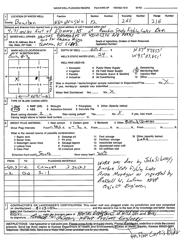
Specific Water Well Detail |
|
|
| Location Info | |||
| Owner: Kansas Dept. of Wildlife and Parks | Status: Plugged | ||
| Location: T26S, R21E, Sec. 12, NE NW SW | County: Bourbon | ||
| Directions: from Elsmore: 4.71 mi E at Bourbon State Fishing Lake Dam | |||
| Latitude: 37.7975078 | Longitude: -95.0639255 | Datum NAD 27 | |
| Latitude: 37.79755 | Longitude: -95.064183 | Datum NAD 83 | |
| Longitude and latitude from GPS measurements. | |||
| GPS Latitude: 37.79755 | GPS Longitude: -95.064183 | Datum WGS84 | |
| View well on interactive map | |||
| General Info | ||
| Well Depth: 60.5 ft. | Elevation: ft. | |
| Static Water Level: 24 ft. | Est. Yield: gpm. | |
| Comp. Date: 13-Aug-2002 | Well Use: Monitoring well/observation/piezometer | |
| DWR Applic. #: | Other ID: | |
| Driller Info | ||
| Driller: KDWP | License #: | |
| Scanned Form | View scan |
| Casing Info | ||
|
Casing Type:
Diam: in. Casing height above land surface: in | ||
| Grout Info | ||
| Grout used: | From: to ft | |
| Source of Possible Contamination | ||
| Source: | ||
| Direction from well: | Distance: ft | |