|
|
|
Specific Water Well Detail |
|
|
| Location Info | |||
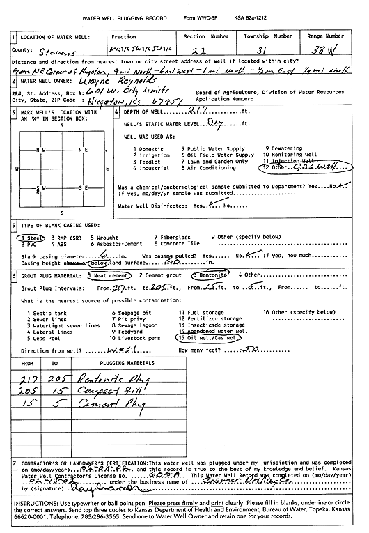
| Owner: Reynolds, Wayne | Status: Plugged | ||
| Location: T31S, R38W, Sec. 22, NE SW SW | County: Stevens | ||
| Directions: from NE corner of Hugoton: 9 mi N, 6 mi W, 1 mi N, .5 mi E, .25 mi N | |||
| Latitude: 37.3327176 | Longitude: -101.4440152 | Datum NAD 27 | |
| Latitude: 37.3327407 | Longitude: -101.4444538 | Datum NAD 83 | |
| Longitude and latitude calculated by Survey from township-range-section-quarter calls. Only good to within the quarter call accuracy. | |||
| View well on interactive map | |||
| General Info | ||
| Well Depth: 217 ft. | Elevation: ft. | |
| Static Water Level: ft. | Est. Yield: gpm. | |
| Comp. Date: 08-Feb-2002 | Well Use: Recovery/Soil Vapor Extraction/Soil Vent | |
| DWR Applic. #: | Other ID: | |
| Driller Info | ||
| Driller: Ray Cramer Drilling Co. | License #: 600 | |
| Scanned Form | View scan |
| Casing Info | ||
|
Casing Type:
Diam: in. Casing height above land surface: in | ||
| Grout Info | ||
| Grout used: | From: to ft | |
| Source of Possible Contamination | ||
| Source: | ||
| Direction from well: | Distance: ft | |