|
|
|
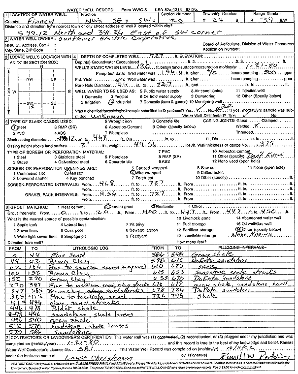
Specific Water Well Detail |
|
|
| Location Info | |||
| Owner: Sunflower Electric Power Corp. | Status: Constructed | ||
| Location: T24S, R34W, Sec. 20, NW SE SW | County: Finney | ||
| Directions: from SW corner: 599.12 feet N and 341.26 feet E | |||
| Latitude: 37.9477974 | Longitude: -101.0785246 | Datum NAD 27 | |
| Latitude: 37.9478202 | Longitude: -101.0789704 | Datum NAD 83 | |
| Longitude and latitude calculated by Survey from township-range-section-quarter calls. Only good to within the quarter call accuracy. | |||
| View well on interactive map | |||
| General Info | ||
| Well Depth: 727 ft. | Elevation: ft. | |
| Static Water Level: 130 ft. | Est. Yield: gpm. | |
| Comp. Date: 21-Jan-1980 | Well Use: Industrial | |
| DWR Applic. #: | Other ID: | |
| Driller Info | ||
| Driller: Layne-Christensen Co. | License #: 581 | |
| Scanned Form | View scan |
|
Chemical Sample Submitted?:
Water Well disinfected?: | ||
| Casing Info | ||
| Casing Type:
Casing Joints: |
Diam: in. to ft | |
| Casing height above land surface: in
Casing Weight: lbs/ft Wall thickness or gauge no.: | ||
| Screen and Perforation Info | ||
| Screen Type: | Screen Openings: | |
| Screen-perforated intervals | From: ft to ft | |
| Gravel pack intervals | From: ft to ft | |
| Grout Info | ||
| Grout used: | From: to ft | |
| Source of Possible Contamination | ||
| Source: | ||
| Direction from well: | Distance: ft | |
| Lithologic Log
(Log data entered by KGS.) | ||
| From: 0 ft. to 44 ft. | fine sand | |
| From: 44 ft. to 62 ft. | brown clay | |
| From: 62 ft. to 106 ft. | fine to coarse sand and gravel | |
| From: 106 ft. to 152 ft. | brown clay | |
| From: 152 ft. to 270 ft. | gray clay | |
| From: 270 ft. to 347 ft. | fine to medium sand, clay streaks | |
| From: 347 ft. to 385 ft. | brown clay, sand streaks | |
| From: 385 ft. to 415 ft. | fine to medium sand | |
| From: 415 ft. to 446 ft. | clay, sand streaks | |
| From: 446 ft. to 478 ft. | black shale | |
| From: 478 ft. to 496 ft. | sandstone, shale lenses | |
| From: 496 ft. to 540 ft. | gray shale | |
| From: 540 ft. to 570 ft. | sandstone, shale lenses | |
| From: 570 ft. to 586 ft. | sandstone | |
| From: 586 ft. to 598 ft. | gray shale | |
| From: 598 ft. to 610 ft. | Dakota sandstone | |
| From: 610 ft. to 625 ft. | Dakota sandstone | |
| From: 625 ft. to 655 ft. | sandstone, shale streaks | |
| From: 655 ft. to 670 ft. | Dakota sandstone | |
| From: 670 ft. to 678 ft. | gray shale, sandstone, hard | |
| From: 678 ft. to 726 ft. | Dakota sandstone | |
| From: 726 ft. to 746 ft. | shale | |