|
|
|
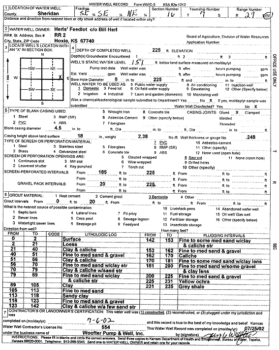
Specific Water Well Detail |
|
|
| Location Info | |||
| Owner: Herls' Feedlot | Status: Constructed | ||
| Location: T7S, R29W, Sec. 16, SE SE NE | County: Sheridan | ||
| Directions: | |||
| Latitude: 39.4455551 | Longitude: -100.5539361 | Datum NAD 27 | |
| Latitude: 39.4455595 | Longitude: -100.5543571 | Datum NAD 83 | |
| Longitude and latitude calculated by Survey from township-range-section-quarter calls. Only good to within the quarter call accuracy. | |||
| View well on interactive map | |||
| General Info | ||
| Well Depth: 225 ft. | Elevation: ft. | |
| Static Water Level: 151 ft. | Est. Yield: gpm. | |
| Comp. Date: 06-Jul-2002 | Well Use: Domestic | |
| DWR Applic. #: | Other ID: | |
| Driller Info | ||
| Driller: Jay C. Woofter Pump & Well, Inc. | License #: 554 | |
| Scanned Form | View scan |
|
Chemical Sample Submitted?:
Water Well disinfected?: | ||
| Casing Info | ||
| Casing Type:
Casing Joints: |
Diam: in. to ft | |
| Casing height above land surface: in
Casing Weight: lbs/ft Wall thickness or gauge no.: | ||
| Screen and Perforation Info | ||
| Screen Type: | Screen Openings: | |
| Screen-perforated intervals | From: ft to ft | |
| Gravel pack intervals | From: ft to ft | |
| Grout Info | ||
| Grout used: | From: to ft | |
| Source of Possible Contamination | ||
| Source: | ||
| Direction from well: | Distance: ft | |
| Lithologic Log
(Log data entered by KGS.) | ||
| From: 0 ft. to 2 ft. | Surface | |
| From: 2 ft. to 21 ft. | Loess | |
| From: 21 ft. to 40 ft. | Clay and caliche | |
| From: 40 ft. to 51 ft. | Fine to medium sand and gravel | |
| From: 51 ft. to 56 ft. | Clay and caliche | |
| From: 56 ft. to 70 ft. | Fine to medium sand with clay streaks | |
| From: 70 ft. to 79 ft. | Clay and caliche with sand streaks | |
| From: 79 ft. to 89 ft. | Fine to medium sand with clay and caliche streaks | |
| From: 89 ft. to 105 ft. | Clay | |
| From: 105 ft. to 113 ft. | Fine to medium sand | |
| From: 113 ft. to 118 ft. | Sandy clay | |
| From: 118 ft. to 123 ft. | Fine to medium sand and gravel | |
| From: 123 ft. to 142 ft. | Clay and caliche with a few sand streaks | |
| From: 142 ft. to 153 ft. | Fine to some medium sand with clay and caliche streaks | |
| From: 153 ft. to 162 ft. | Fine to medium sand and gravel | |
| From: 162 ft. to 170 ft. | Caliche | |
| From: 170 ft. to 181 ft. | Fine to some medium sand with clay lens | |
| From: 181 ft. to 200 ft. | Fine to medium sand with some gravel and clay lens | |
| From: 200 ft. to 225 ft. | Fine to medium sand and gravel | |
| From: 225 ft. to 231 ft. | Yellow ochre | |
| From: 231 ft. to 235 ft. | gray shale | |