|
|
|
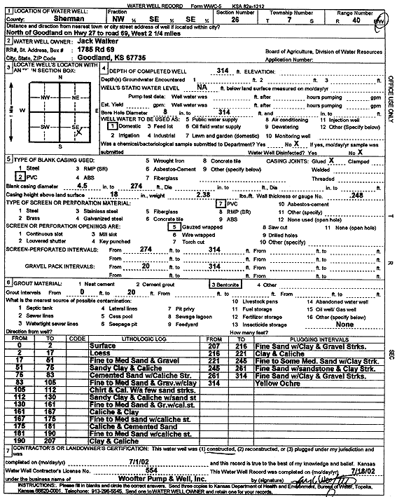
Specific Water Well Detail |
|
|
| Location Info | |||
| Owner: Walker, Jack | Status: Constructed | ||
| Location: T7S, R40W, Sec. 26, NW SE SE | County: Sherman | ||
| Directions: from Goodland: N on Hwy 27 to Rd 69, W 2.25 mi | |||
| Latitude: 39.411909 | Longitude: -101.7472045 | Datum NAD 27 | |
| Latitude: 39.4119072 | Longitude: -101.7476556 | Datum NAD 83 | |
| Longitude and latitude calculated by Survey from township-range-section-quarter calls. Only good to within the quarter call accuracy. | |||
| View well on interactive map | |||
| General Info | ||
| Well Depth: 314 ft. | Elevation: ft. | |
| Static Water Level: ft. | Est. Yield: gpm. | |
| Comp. Date: 01-Jul-2002 | Well Use: Domestic | |
| DWR Applic. #: | Other ID: | |
| Driller Info | ||
| Driller: Jay C. Woofter Pump & Well, Inc. | License #: 554 | |
| Scanned Form | View scan |
|
Chemical Sample Submitted?:
Water Well disinfected?: | ||
| Casing Info | ||
| Casing Type:
Casing Joints: |
Diam: in. to ft | |
| Casing height above land surface: in
Casing Weight: lbs/ft Wall thickness or gauge no.: | ||
| Screen and Perforation Info | ||
| Screen Type: | Screen Openings: | |
| Screen-perforated intervals | From: ft to ft | |
| Gravel pack intervals | From: ft to ft | |
| Grout Info | ||
| Grout used: | From: to ft | |
| Source of Possible Contamination | ||
| Source: | ||
| Direction from well: | Distance: ft | |
| Lithologic Log
(Log data entered by KGS.) | ||
| From: 0 ft. to 2 ft. | Surface | |
| From: 2 ft. to 17 ft. | Loess | |
| From: 17 ft. to 51 ft. | Fine to medium sand and gravel | |
| From: 51 ft. to 76 ft. | Sandy clay and caliche | |
| From: 76 ft. to 83 ft. | Cemented sand with caliche streaks | |
| From: 83 ft. to 105 ft. | Fine to medium sand and gravel with clay | |
| From: 105 ft. to 112 ft. | Chert and caliche with a few sand streaks | |
| From: 112 ft. to 130 ft. | Sandy clay and caliche with sand streaks | |
| From: 130 ft. to 161 ft. | Fine to medium sand and gravel with caliche streaks | |
| From: 161 ft. to 190 ft. | Fine to medium sand with caliche streaks | |
| From: 190 ft. to 207 ft. | Clay and caliche | |
| From: 207 ft. to 216 ft. | Fine sand with clay and gravel streaks | |
| From: 216 ft. to 221 ft. | Clay and caliche | |
| From: 221 ft. to 245 ft. | Fine to some medium sand with clay streaks | |
| From: 245 ft. to 261 ft. | Fine sand with sandstone and clay streak | |
| From: 261 ft. to 314 ft. | Fine sand with clay and gravel streaks | |
| From: 314 ft. to ft. | Yellow ochre | |