|
|
|
Specific Water Well Detail |
|
|
| Location Info | |||
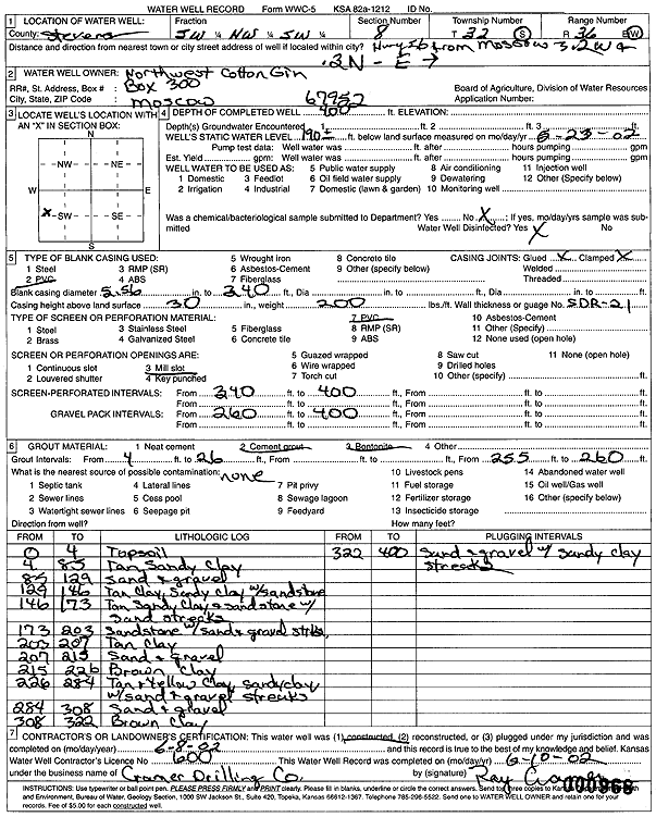
| Owner: Northwest Cotton Gin | Status: Constructed | ||
| Location: T32S, R36W, Sec. 8, SW NW SW | County: Stevens | ||
| Directions: from Moscow: 3.2 mi W on Hwy 56, .3 mi N, E | |||
| Latitude: 37.2761177 | Longitude: -101.265355 | Datum NAD 27 | |
| Latitude: 37.2761415 | Longitude: -101.2657902 | Datum NAD 83 | |
| Longitude and latitude calculated by Survey from township-range-section-quarter calls. Only good to within the quarter call accuracy. | |||
| View well on interactive map | |||
| General Info | ||
| Well Depth: 400 ft. | Elevation: ft. | |
| Static Water Level: 190 ft. | Est. Yield: gpm. | |
| Comp. Date: 08-Jun-2002 | Well Use: (unstated)/abandoned | |
| DWR Applic. #: | Other ID: | |
| Driller Info | ||
| Driller: Ray Cramer Drilling Co. | License #: 600 | |
| Scanned Form | View scan |
|
Chemical Sample Submitted?:
Water Well disinfected?: | ||
| Casing Info | ||
| Casing Type:
Casing Joints: |
Diam: in. to ft | |
| Casing height above land surface: in
Casing Weight: lbs/ft Wall thickness or gauge no.: | ||
| Screen and Perforation Info | ||
| Screen Type: | Screen Openings: | |
| Screen-perforated intervals | From: ft to ft | |
| Gravel pack intervals | From: ft to ft | |
| Grout Info | ||
| Grout used: | From: to ft | |
| Source of Possible Contamination | ||
| Source: | ||
| Direction from well: | Distance: ft | |
| Lithologic Log
(Log data entered by KGS.) | ||
| From: 0 ft. to 4 ft. | topsoil | |
| From: 4 ft. to 85 ft. | tan sandy clay | |
| From: 85 ft. to 129 ft. | sand and gravel | |
| From: 129 ft. to 146 ft. | tan clay, sandy clay with sandstone | |
| From: 146 ft. to 173 ft. | tan sandy clay and sandstone with sand streaks | |
| From: 173 ft. to 203 ft. | sandstone with sand and gravel streaks | |
| From: 203 ft. to 207 ft. | tan clay | |
| From: 207 ft. to 215 ft. | sand and gravel | |
| From: 215 ft. to 226 ft. | brown clay | |
| From: 226 ft. to 284 ft. | tan and yellow clay, sandy clay with sand and gravel streaks | |
| From: 284 ft. to 308 ft. | sand and gravel | |
| From: 308 ft. to 322 ft. | brown clay | |
| From: 322 ft. to 400 ft. | sand and gravel with sandy clay streaks | |