|
|
|
Specific Water Well Detail |
|
|
| Location Info | |||
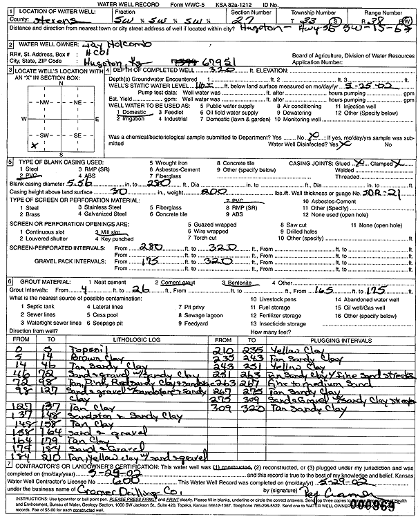
| Owner: Holcomb, Jay | Status: Constructed | ||
| Location: T33S, R38W, Sec. 27, SW SW SW | County: Stevens | ||
| Directions: from Hugoton: 5 mi W on Hwy 56, 1 mi S, E | |||
| Latitude: 37.141953 | Longitude: -101.4456588 | Datum NAD 27 | |
| Latitude: 37.1419785 | Longitude: -101.4460953 | Datum NAD 83 | |
| Longitude and latitude calculated by Survey from township-range-section-quarter calls. Only good to within the quarter call accuracy. | |||
| View well on interactive map | |||
| General Info | ||
| Well Depth: 320 ft. | Elevation: ft. | |
| Static Water Level: 116 ft. | Est. Yield: gpm. | |
| Comp. Date: 25-May-2002 | Well Use: Domestic | |
| DWR Applic. #: | Other ID: | |
| Driller Info | ||
| Driller: Ray Cramer Drilling Co. | License #: 600 | |
| Scanned Form | View scan |
|
Chemical Sample Submitted?:
Water Well disinfected?: | ||
| Casing Info | ||
| Casing Type:
Casing Joints: |
Diam: in. to ft | |
| Casing height above land surface: in
Casing Weight: lbs/ft Wall thickness or gauge no.: | ||
| Screen and Perforation Info | ||
| Screen Type: | Screen Openings: | |
| Screen-perforated intervals | From: ft to ft | |
| Gravel pack intervals | From: ft to ft | |
| Grout Info | ||
| Grout used: | From: to ft | |
| Source of Possible Contamination | ||
| Source: | ||
| Direction from well: | Distance: ft | |
| Lithologic Log
(Log data entered by KGS.) | ||
| From: 0 ft. to 5 ft. | topsoil | |
| From: 5 ft. to 14 ft. | brown clay | |
| From: 14 ft. to 46 ft. | tan sandy clay | |
| From: 46 ft. to 72 ft. | sand and gravel with sandy clay | |
| From: 72 ft. to 98 ft. | tan, pink, red sandy clay and sandstone | |
| From: 98 ft. to 127 ft. | sand and gravel with sandstone and sandy clay | |
| From: 127 ft. to 137 ft. | tan clay | |
| From: 137 ft. to 148 ft. | sandstone and sandy clay | |
| From: 148 ft. to 158 ft. | tan clay | |
| From: 158 ft. to 164 ft. | sand and gravel | |
| From: 164 ft. to 179 ft. | tan clay | |
| From: 179 ft. to 184 ft. | sand and gravel | |
| From: 184 ft. to 210 ft. | tan, yellow clay with sand and gravel | |
| From: 210 ft. to 235 ft. | yellow clay | |
| From: 235 ft. to 243 ft. | tan sandy clay | |
| From: 243 ft. to 251 ft. | yellow clay | |
| From: 251 ft. to 263 ft. | tan sandy clay with fine sand streaks | |
| From: 263 ft. to 267 ft. | fine to medium sand | |
| From: 267 ft. to 275 ft. | tan sandy clay | |
| From: 275 ft. to 309 ft. | sand and gravel with sandy clay streaks | |
| From: 309 ft. to 320 ft. | tan sandy clay | |