|
|
|
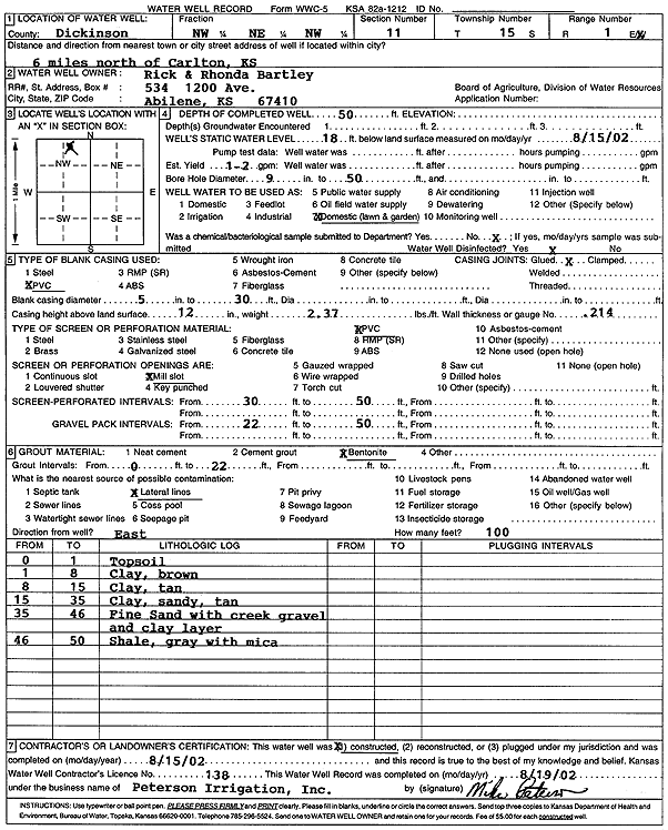
Specific Water Well Detail |
|
|
| Location Info | |||
| Owner: Bartley, Rick and Rhonda | Status: Constructed | ||
| Location: T15S, R1E, Sec. 11, NW NE NW | County: Dickinson | ||
| Directions: from Carlton: 6 mi N | |||
| Latitude: 38.7681175 | Longitude: -97.2920591 | Datum NAD 27 | |
| Latitude: 38.7681194 | Longitude: -97.2923614 | Datum NAD 83 | |
| Longitude and latitude calculated by Survey from township-range-section-quarter calls. Only good to within the quarter call accuracy. | |||
| View well on interactive map | |||
| General Info | ||
| Well Depth: 50 ft. | Elevation: ft. | |
| Static Water Level: 18 ft. | Est. Yield: 2 gpm. | |
| Comp. Date: 15-Aug-2002 | Well Use: Domestic, Lawn and Garden | |
| DWR Applic. #: | Other ID: | |
| Driller Info | ||
| Driller: Michael Peterson Irrigation, Inc. | License #: 138 | |
| Scanned Form | View scan |
|
Chemical Sample Submitted?:
Water Well disinfected?: | ||
| Casing Info | ||
| Casing Type:
Casing Joints: |
Diam: in. to ft | |
| Casing height above land surface: in
Casing Weight: lbs/ft Wall thickness or gauge no.: | ||
| Screen and Perforation Info | ||
| Screen Type: | Screen Openings: | |
| Screen-perforated intervals | From: ft to ft | |
| Gravel pack intervals | From: ft to ft | |
| Grout Info | ||
| Grout used: | From: to ft | |
| Source of Possible Contamination | ||
| Source: | ||
| Direction from well: | Distance: ft | |
| Lithologic Log
(Log data entered by KGS.) | ||
| From: 0 ft. to 1 ft. | top soil | |
| From: 1 ft. to 8 ft. | clay, brown | |
| From: 8 ft. to 15 ft. | clay, tan | |
| From: 15 ft. to 35 ft. | sandy clay, tan | |
| From: 35 ft. to 46 ft. | fine sand with creek gravel and clay layer | |
| From: 46 ft. to 50 ft. | shale, gray, with mica | |