|
|
|
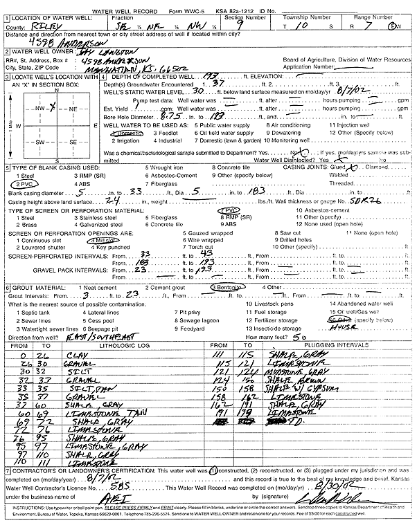
Specific Water Well Detail |
|
|
| Location Info | |||
| Owner: Langton, Jay | Status: Constructed | ||
| Location: T10S, R7E, Sec. 9, SE NE NW | County: Riley | ||
| Directions: 4598 Anderson, Manhattan | |||
| Latitude: 39.2011927 | Longitude: -96.6549958 | Datum NAD 27 | |
| Latitude: 39.2011894 | Longitude: -96.6552785 | Datum NAD 83 | |
| Longitude and latitude calculated by Survey from township-range-section-quarter calls. Only good to within the quarter call accuracy. | |||
| View well on interactive map | |||
| General Info | ||
| Well Depth: 193 ft. | Elevation: ft. | |
| Static Water Level: 30 ft. | Est. Yield: 1 gpm. | |
| Comp. Date: 07-Aug-2002 | Well Use: Domestic | |
| DWR Applic. #: | Other ID: | |
| Driller Info | ||
| Driller: Associated Environmental, Inc. | License #: 585 | |
| Scanned Form | View scan |
|
Chemical Sample Submitted?:
Water Well disinfected?: | ||
| Casing Info | ||
| Casing Type:
Casing Joints: |
Diam: in. to ft | |
| Casing height above land surface: in
Casing Weight: lbs/ft Wall thickness or gauge no.: | ||
| Screen and Perforation Info | ||
| Screen Type: | Screen Openings: | |
| Screen-perforated intervals | From: ft to ft | |
| Gravel pack intervals | From: ft to ft | |
| Grout Info | ||
| Grout used: | From: to ft | |
| Source of Possible Contamination | ||
| Source: | ||
| Direction from well: | Distance: ft | |
| Lithologic Log
(Log data entered by KGS.) | ||
| From: 0 ft. to 26 ft. | clay | |
| From: 26 ft. to 30 ft. | gravel | |
| From: 30 ft. to 32 ft. | silt | |
| From: 32 ft. to 33 ft. | gravel | |
| From: 33 ft. to 35 ft. | silt, tan | |
| From: 35 ft. to 37 ft. | gravel | |
| From: 37 ft. to 60 ft. | shale, gray | |
| From: 60 ft. to 69 ft. | limestone, tan | |
| From: 69 ft. to 72 ft. | shale, gray | |
| From: 72 ft. to 76 ft. | limestone | |
| From: 76 ft. to 95 ft. | shale, gray | |
| From: 95 ft. to 97 ft. | limestone, gray | |
| From: 97 ft. to 110 ft. | shale, gray | |
| From: 110 ft. to 111 ft. | limestone | |
| From: 111 ft. to 115 ft. | shale, gray | |
| From: 115 ft. to 121 ft. | limestone | |
| From: 121 ft. to 124 ft. | mudstone, gray | |
| From: 124 ft. to 150 ft. | shale, brown | |
| From: 150 ft. to 158 ft. | shale with gypsum | |
| From: 158 ft. to 162 ft. | limestone | |
| From: 162 ft. to 191 ft. | shale, gray | |
| From: 191 ft. to 193 ft. | limestone | |