|
|
|
Specific Water Well Detail |
|
|
| Location Info | |||
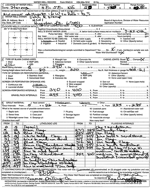
| Owner: Slemp, John R. | Status: Constructed | ||
| Location: T33S, R38W, Sec. 20, SE SE NE | County: Stevens | ||
| Directions: from SW corner of Hugoton: 6 mi W to 6 Rd, .5 mi S | |||
| Latitude: 37.1636639 | Longitude: -101.4661176 | Datum NAD 27 | |
| Latitude: 37.1636891 | Longitude: -101.4665538 | Datum NAD 83 | |
| Longitude and latitude calculated by Survey from township-range-section-quarter calls. Only good to within the quarter call accuracy. | |||
| View well on interactive map | |||
| General Info | ||
| Well Depth: 400 ft. | Elevation: ft. | |
| Static Water Level: ft. | Est. Yield: gpm. | |
| Comp. Date: 04-Jul-2002 | Well Use: Domestic | |
| DWR Applic. #: | Other ID: | |
| Driller Info | ||
| Driller: Ray Cramer Drilling Co. | License #: 600 | |
| Scanned Form | View scan |
|
Chemical Sample Submitted?:
Water Well disinfected?: | ||
| Casing Info | ||
| Casing Type:
Casing Joints: |
Diam: in. to ft | |
| Casing height above land surface: in
Casing Weight: lbs/ft Wall thickness or gauge no.: | ||
| Screen and Perforation Info | ||
| Screen Type: | Screen Openings: | |
| Screen-perforated intervals | From: ft to ft | |
| Gravel pack intervals | From: ft to ft | |
| Grout Info | ||
| Grout used: | From: to ft | |
| Source of Possible Contamination | ||
| Source: | ||
| Direction from well: | Distance: ft | |
| Lithologic Log
(Log data entered by KGS.) | ||
| From: 0 ft. to 5 ft. | topsoil | |
| From: 5 ft. to 12 ft. | brown clay | |
| From: 12 ft. to 23 ft. | blue clay | |
| From: 23 ft. to 31 ft. | white sandy clay | |
| From: 31 ft. to 37 ft. | fine to medium sand | |
| From: 37 ft. to 43 ft. | blue clay | |
| From: 43 ft. to 97 ft. | brown clay with sandstone streaks | |
| From: 97 ft. to 139 ft. | brown sandy clay with fine sand | |
| From: 139 ft. to 148 ft. | fine to medium sand | |
| From: 148 ft. to 172 ft. | tan clay with sandstone | |
| From: 172 ft. to 216 ft. | tan clay | |
| From: 216 ft. to 237 ft. | tan sandy clay with fine sand, sandstone | |
| From: 237 ft. to 259 ft. | tan clay with sandstone streaks | |
| From: 259 ft. to 277 ft. | fine to medium sand with tan sandy clay and sandstone | |
| From: 277 ft. to 284 ft. | tan sandy clay | |
| From: 284 ft. to 297 ft. | tan clay | |
| From: 297 ft. to 304 ft. | fine sand and sandstone | |
| From: 304 ft. to 316 ft. | tan clay | |
| From: 316 ft. to 321 ft. | tan sandy clay | |
| From: 321 ft. to 337 ft. | fine sand and sandstone | |
| From: 337 ft. to 359 ft. | tan sandy clay with fine to medium sand streaks | |
| From: 359 ft. to 400 ft. | medium to coarse sand with sandstone and cemented gravel | |