|
|
|
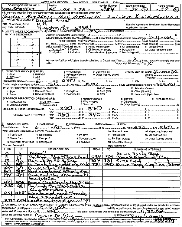
Specific Water Well Detail |
|
|
| Location Info | |||
| Owner: Donald Knier | Status: Constructed | ||
| Location: T34S, R37W, Sec. 34, SE SE SE | County: Stevens | ||
| Directions: from Hugoton: Hwy 25 and 51: 10 mi N on 25, 2 mi W, .5 mi N, and W | |||
| Latitude: 37.0403422 | Longitude: -101.321113 | Datum NAD 27 | |
| Latitude: 37.0403683 | Longitude: -101.3215517 | Datum NAD 83 | |
| Longitude and latitude calculated by Survey from township-range-section-quarter calls. Only good to within the quarter call accuracy. | |||
| View well on interactive map | |||
| General Info | ||
| Well Depth: 340 ft. | Elevation: ft. | |
| Static Water Level: 195 ft. | Est. Yield: gpm. | |
| Comp. Date: 16-Jul-2002 | Well Use: Domestic | |
| DWR Applic. #: | Other ID: | |
| Driller Info | ||
| Driller: Ray Cramer Drilling Co. | License #: 600 | |
| Scanned Form | View scan |
|
Chemical Sample Submitted?:
Water Well disinfected?: | ||
| Casing Info | ||
| Casing Type:
Casing Joints: |
Diam: in. to ft | |
| Casing height above land surface: in
Casing Weight: lbs/ft Wall thickness or gauge no.: | ||
| Screen and Perforation Info | ||
| Screen Type: | Screen Openings: | |
| Screen-perforated intervals | From: ft to ft | |
| Gravel pack intervals | From: ft to ft | |
| Grout Info | ||
| Grout used: | From: to ft | |
| Source of Possible Contamination | ||
| Source: | ||
| Direction from well: | Distance: ft | |
| Lithologic Log
(Log data entered by KGS.) | ||
| From: 0 ft. to 3 ft. | topsoil | |
| From: 3 ft. to 17 ft. | tan sandy clay with fine sand | |
| From: 17 ft. to 56 ft. | tan and white sandy clay | |
| From: 56 ft. to 128 ft. | tan sandy clay, sandstone, rock | |
| From: 128 ft. to 167 ft. | brown and tan clay | |
| From: 167 ft. to 198 ft. | rock and sandstone with sandy clay | |
| From: 198 ft. to 214 ft. | brown sandy clay with fine sand and sandstone | |
| From: 214 ft. to 232 ft. | brown clay with sandy clay streaks | |
| From: 232 ft. to 251 ft. | tan sandy clay with fine sand and clay streaks | |
| From: 251 ft. to 278 ft. | fine to medium sand with sandy clay and sandstone | |
| From: 278 ft. to 294 ft. | coarse sand small gravel with brown sandy clay | |
| From: 294 ft. to 324 ft. | brown and blue sandy clay | |
| From: 324 ft. to 331 ft. | fine sand | |
| From: 331 ft. to 340 ft. | brown sandy clay and sandstone | |