|
|
|
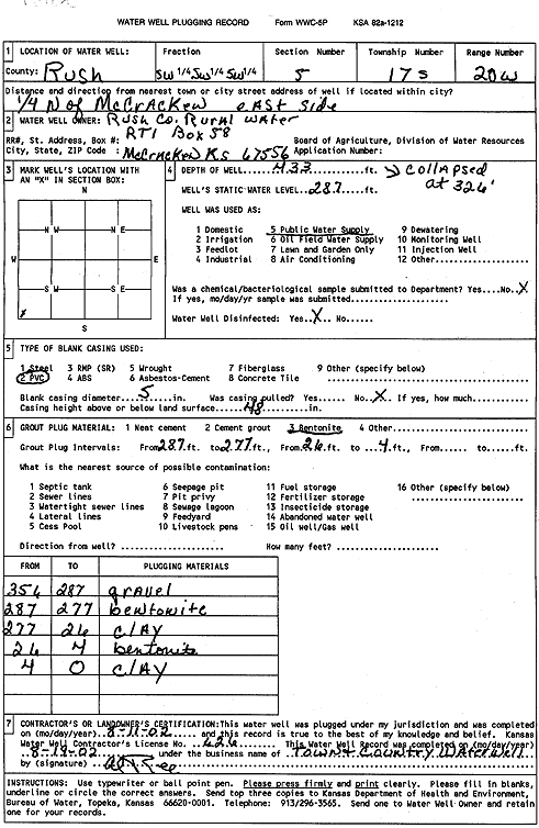
Specific Water Well Detail |
|
|
| Location Info | |||
| Owner: Rush Co. RWD | Status: Plugged | ||
| Location: T17S, R20W, Sec. 5, SW SW SW | County: Rush | ||
| Directions: from McCrackew: .25 mi N, ESR | |||
| Latitude: 38.5975381 | Longitude: -99.5672189 | Datum NAD 27 | |
| Latitude: 38.5975518 | Longitude: -99.56761 | Datum NAD 83 | |
| Longitude and latitude calculated by Survey from township-range-section-quarter calls. Only good to within the quarter call accuracy. | |||
| View well on interactive map | |||
| General Info | ||
| Well Depth: 433 ft. | Elevation: ft. | |
| Static Water Level: 287 ft. | Est. Yield: gpm. | |
| Comp. Date: 11-Aug-2002 | Well Use: Public Water Supply | |
| DWR Applic. #: | Other ID: | |
| Links | |
| No Wizard information available. | |
| View info from WIMAS Water Right Data base... | |
| Driller Info | ||
| Driller: Town & Country WW Srvc | License #: 626 | |
| Scanned Form | View scan |
| Casing Info | ||
|
Casing Type:
Diam: in. Casing height above land surface: in | ||
| Grout Info | ||
| Grout used: | From: to ft | |
| Source of Possible Contamination | ||
| Source: | ||
| Direction from well: | Distance: ft | |