|
|
|
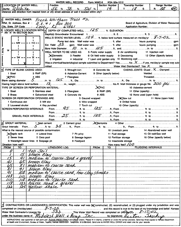
Specific Water Well Detail |
|
|
| Location Info | |||
| Owner: Frank E. Whitham Trust No. 2 | Status: Constructed | ||
| Location: T18S, R38W, Sec. 14, SE SE SW | County: Wichita | ||
| Directions: | |||
| Latitude: 38.4820033 | Longitude: -101.4861683 | Datum NAD 27 | |
| Latitude: 38.4820203 | Longitude: -101.4866103 | Datum NAD 83 | |
| Longitude and latitude calculated by Survey from township-range-section-quarter calls. Only good to within the quarter call accuracy. | |||
| View well on interactive map | |||
| General Info | ||
| Well Depth: 125 ft. | Elevation: ft. | |
| Static Water Level: 104 ft. | Est. Yield: 33 gpm. | |
| Comp. Date: 07-Aug-2002 | Well Use: Domestic | |
| DWR Applic. #: | Other ID: | |
| Driller Info | ||
| Driller: Midwest Well & Pump, Inc. | License #: 532 | |
| Scanned Form | View scan |
|
Chemical Sample Submitted?:
Water Well disinfected?: | ||
| Casing Info | ||
| Casing Type:
Casing Joints: |
Diam: in. to ft | |
| Casing height above land surface: in
Casing Weight: lbs/ft Wall thickness or gauge no.: | ||
| Screen and Perforation Info | ||
| Screen Type: | Screen Openings: | |
| Screen-perforated intervals | From: ft to ft | |
| Gravel pack intervals | From: ft to ft | |
| Grout Info | ||
| Grout used: | From: to ft | |
| Source of Possible Contamination | ||
| Source: | ||
| Direction from well: | Distance: ft | |
| Lithologic Log
(Log data entered by KGS.) | ||
| From: 0 ft. to 1 ft. | Top soil | |
| From: 1 ft. to 15 ft. | Brown clay | |
| From: 15 ft. to 41 ft. | Medium to coarse sand and gravel | |
| From: 41 ft. to 65 ft. | Brown clay | |
| From: 65 ft. to 81 ft. | Medium to coarse sand | |
| From: 81 ft. to 91 ft. | Brown clay | |
| From: 91 ft. to 108 ft. | Medium to coarse sand, few clay streaks | |
| From: 108 ft. to 110 ft. | Brown clay | |
| From: 110 ft. to 118 ft. | Medium to coarse sand | |
| From: 118 ft. to 122 ft. | Coarse sand and gravel | |
| From: 122 ft. to 125 ft. | Yellow shale | |