|
|
|
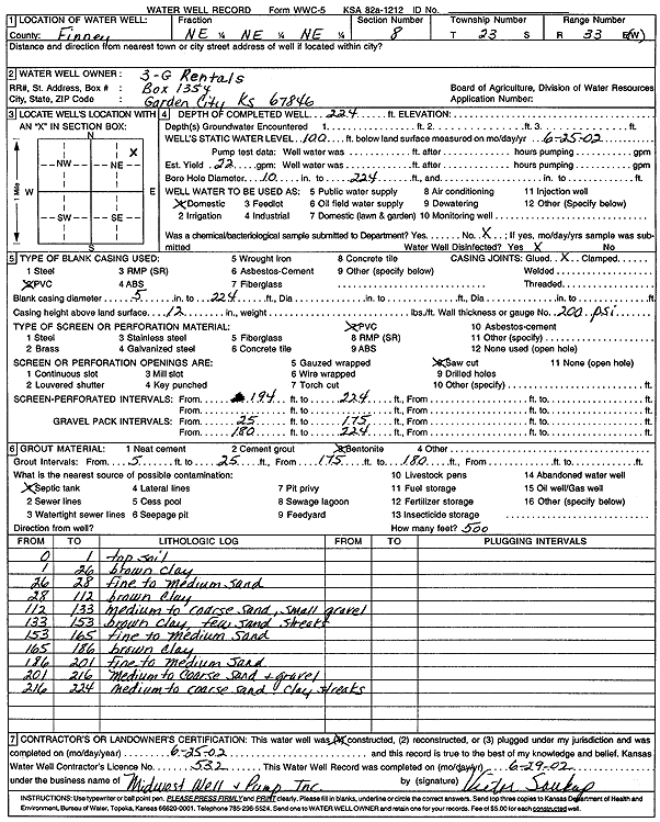
Specific Water Well Detail |
|
|
| Location Info | |||
| Owner: 3-G Rentals | Status: Constructed | ||
| Location: T23S, R33W, Sec. 8, NE NE NE | County: Finney | ||
| Directions: | |||
| Latitude: 38.075356 | Longitude: -100.9574689 | Datum NAD 27 | |
| Latitude: 38.0753795 | Longitude: -100.9579098 | Datum NAD 83 | |
| Longitude and latitude calculated by Survey from township-range-section-quarter calls. Only good to within the quarter call accuracy. | |||
| View well on interactive map | |||
| General Info | ||
| Well Depth: 224 ft. | Elevation: ft. | |
| Static Water Level: 100 ft. | Est. Yield: 22 gpm. | |
| Comp. Date: 25-Jun-2002 | Well Use: Domestic | |
| DWR Applic. #: | Other ID: | |
| Driller Info | ||
| Driller: R. S. Glaze Drilling | License #: 632 | |
| Scanned Form | View scan |
|
Chemical Sample Submitted?:
Water Well disinfected?: | ||
| Casing Info | ||
| Casing Type:
Casing Joints: |
Diam: in. to ft | |
| Casing height above land surface: in
Casing Weight: lbs/ft Wall thickness or gauge no.: | ||
| Screen and Perforation Info | ||
| Screen Type: | Screen Openings: | |
| Screen-perforated intervals | From: ft to ft | |
| Gravel pack intervals | From: ft to ft | |
| Grout Info | ||
| Grout used: | From: to ft | |
| Source of Possible Contamination | ||
| Source: | ||
| Direction from well: | Distance: ft | |
| Lithologic Log
(Log data entered by KGS.) | ||
| From: 0 ft. to 1 ft. | top soil | |
| From: 1 ft. to 26 ft. | brown clay | |
| From: 26 ft. to 28 ft. | fine to medium sand | |
| From: 28 ft. to 112 ft. | brown clay | |
| From: 112 ft. to 133 ft. | medium to coarse sand, small gravel | |
| From: 133 ft. to 153 ft. | brown clay, few sand streaks | |
| From: 153 ft. to 165 ft. | fine to medium sand | |
| From: 165 ft. to 186 ft. | brown clay | |
| From: 186 ft. to 201 ft. | fine to medium sand | |
| From: 201 ft. to 216 ft. | medium to coarse sand and gravel | |
| From: 216 ft. to 224 ft. | medium to coarse sand, clay streaks | |