|
|
|
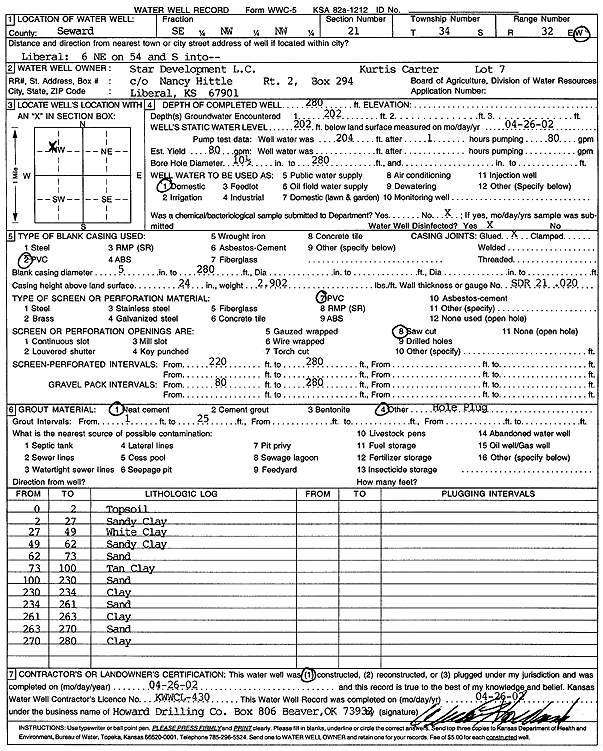
Specific Water Well Detail |
|
|
| Location Info | |||
| Owner: Star Development, L.C. | Status: Constructed | ||
| Location: T34S, R32W, Sec. 21, SE NW NW | County: Seward | ||
| Directions: from Liberal: 6 mi NE on 54, S into site | |||
| Latitude: 37.08022 | Longitude: -100.8105788 | Datum NAD 27 | |
| Latitude: 37.080244 | Longitude: -100.8110178 | Datum NAD 83 | |
| Longitude and latitude calculated by Survey from township-range-section-quarter calls. Only good to within the quarter call accuracy. | |||
| View well on interactive map | |||
| General Info | ||
| Well Depth: 280 ft. | Elevation: ft. | |
| Static Water Level: 202 ft. | Est. Yield: 80 gpm. | |
| Comp. Date: 26-Apr-2002 | Well Use: Domestic | |
| DWR Applic. #: | Other ID: | |
| Driller Info | ||
| Driller: Howard Drilling Company AG, LLC | License #: 430 | |
| Scanned Form | View scan |
|
Chemical Sample Submitted?:
Water Well disinfected?: | ||
| Casing Info | ||
| Casing Type:
Casing Joints: |
Diam: in. to ft | |
| Casing height above land surface: in
Casing Weight: lbs/ft Wall thickness or gauge no.: | ||
| Screen and Perforation Info | ||
| Screen Type: | Screen Openings: | |
| Screen-perforated intervals | From: ft to ft | |
| Gravel pack intervals | From: ft to ft | |
| Grout Info | ||
| Grout used: | From: to ft | |
| Source of Possible Contamination | ||
| Source: | ||
| Direction from well: | Distance: ft | |
| Lithologic Log
(Log data entered by KGS.) | ||
| From: 0 ft. to 2 ft. | topsoil | |
| From: 2 ft. to 27 ft. | sandy clay | |
| From: 27 ft. to 49 ft. | white clay | |
| From: 49 ft. to 62 ft. | sandy clay | |
| From: 62 ft. to 73 ft. | sand | |
| From: 73 ft. to 100 ft. | tan clay | |
| From: 100 ft. to 230 ft. | sand | |
| From: 230 ft. to 234 ft. | clay | |
| From: 234 ft. to 261 ft. | sand | |
| From: 261 ft. to 263 ft. | clay | |
| From: 263 ft. to 270 ft. | sand | |
| From: 270 ft. to 280 ft. | clay | |