|
|
|
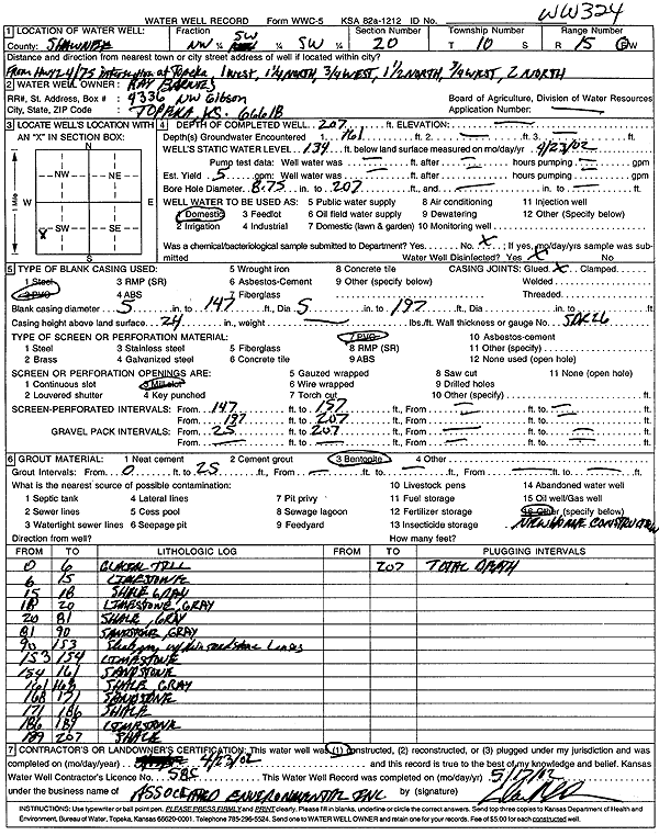
Specific Water Well Detail |
|
|
| Location Info | |||
| Owner: Barnes, Ray | Status: Constructed | ||
| Location: T10S, R15E, Sec. 20, NW SW SW | County: Shawnee | ||
| Directions: from Hwy 24 and Hwy 75: 1 mi W, 1.25 mi N, .75 mi W, 1.5 mi N, .75 mi W, 2 mi N, Topeka | |||
| Latitude: 39.1613235 | Longitude: -95.7738315 | Datum NAD 27 | |
| Latitude: 39.1613219 | Longitude: -95.7740936 | Datum NAD 83 | |
| Longitude and latitude calculated by Survey from township-range-section-quarter calls. Only good to within the quarter call accuracy. | |||
| View well on interactive map | |||
| General Info | ||
| Well Depth: 207 ft. | Elevation: ft. | |
| Static Water Level: 134 ft. | Est. Yield: 5 gpm. | |
| Comp. Date: 23-Apr-2002 | Well Use: Domestic | |
| DWR Applic. #: | Other ID: WW 324 | |
| Driller Info | ||
| Driller: Associated Environmental, Inc. | License #: 585 | |
| Scanned Form | View scan |
|
Chemical Sample Submitted?:
Water Well disinfected?: | ||
| Casing Info | ||
| Casing Type:
Casing Joints: |
Diam: in. to ft | |
| Casing height above land surface: in
Casing Weight: lbs/ft Wall thickness or gauge no.: | ||
| Screen and Perforation Info | ||
| Screen Type: | Screen Openings: | |
| Screen-perforated intervals | From: ft to ft | |
| Gravel pack intervals | From: ft to ft | |
| Grout Info | ||
| Grout used: | From: to ft | |
| Source of Possible Contamination | ||
| Source: | ||
| Direction from well: | Distance: ft | |
| Lithologic Log
(Log data entered by KGS.) | ||
| From: 0 ft. to 6 ft. | glacial till | |
| From: 6 ft. to 15 ft. | limestone | |
| From: 15 ft. to 18 ft. | shale, gray | |
| From: 18 ft. to 20 ft. | limestone, gray | |
| From: 20 ft. to 81 ft. | shale, gray | |
| From: 81 ft. to 90 ft. | sandstone, gray | |
| From: 90 ft. to 153 ft. | shale, gray, with thin sandstone lenses | |
| From: 153 ft. to 154 ft. | limestone | |
| From: 154 ft. to 161 ft. | sandstone | |
| From: 161 ft. to 168 ft. | shale, gray | |
| From: 168 ft. to 171 ft. | sandstone | |
| From: 171 ft. to 186 ft. | shale | |
| From: 186 ft. to 189 ft. | limestone | |
| From: 189 ft. to 207 ft. | shale | |