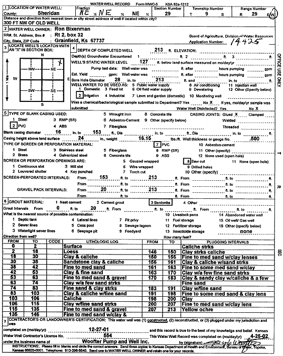
KGS Home Page Water Well Data base Specific Water Well Detail
Water Resources

Well T9S, R29W, Sec. 29, NE NE NE, Action: Constructed

Location Info
Owner: Bixenman, Ron Status: Constructed
Location: T9S, R29W, Sec. 29, NE NE NE County: Sheridan
Directions: from Old well: 300' NW
Latitude: 39.2480201 Longitude: -100.5734136 Datum NAD 27
Latitude: 39.2480264 Longitude: -100.5738344 Datum NAD 83
Longitude and latitude calculated by Survey from township-range-section-quarter calls. Only good to within the quarter call accuracy.
View well on interactive map
General Info
Well Depth: 213 ft. Elevation: ft.
Static Water Level: 127 ft. Est. Yield: gpm.
Comp. Date: 27-Dec-2001 Well Use: Irrigation
DWR Applic. #: 14425 Other ID:
Links
No Wizard information available.
View info from WIMAS Water Right Data base...
Driller Info
Driller: Jay C. Woofter Pump & Well, Inc. License #: 554
Scanned Form
View form(s) on screen Download scan(s)
The download files contain one or more TIFF images compressed into a ZIP archive. Your browser may be already set up to decompress these files. The TIFFs are 300 dpi archival-quality scans of the WWC5 forms and can be viewed by software like Adobe PhotoShop.
Chemical Sample Submitted?:
Water Well disinfected?:
Casing Info
Casing Type:
Casing Joints:
Diam: in. to ft
Casing height above land surface: in
Casing Weight: lbs/ft
Wall thickness or gauge no.:
Screen and Perforation Info
Screen Type: Screen Openings:
Screen-perforated intervals From: ft to ft
Gravel pack intervals From: ft to ft
Grout Info
Grout used: From: to ft
Source of Possible Contamination
Source:
Direction from well: Distance: ft
Lithologic Log
(Log data entered by KGS.)
From: 0 ft. to 2 ft. Surface
From: 2 ft. to 18 ft. Loess
From: 18 ft. to 30 ft. Clay and caliche
From: 30 ft. to 38 ft. Sandstone clay and caliche
From: 38 ft. to 42 ft. Fine to medium sand
From: 42 ft. to 53 ft. Clay and fine sand
From: 53 ft. to 63 ft. Fine to medium sand and gravel
From: 63 ft. to 74 ft. Clay with a few sand streaks
From: 74 ft. to 83 ft. Fine sand and clay streaks
From: 83 ft. to 103 ft. Clay and caliche with fine sand
From: 103 ft. to 106 ft. Caliche
From: 106 ft. to 115 ft. Clay with fine sand streaks
From: 115 ft. to 135 ft. Fine to medium sand and gravel
From: 135 ft. to 146 ft. Fine to medium sand with clay and caliche streaks
From: 146 ft. to 150 ft. Clay streaks caliche
From: 150 ft. to 156 ft. Fine to medium sand with clay lenses
From: 156 ft. to 161 ft. Clay and caliche with sand streaks
From: 161 ft. to 163 ft. Fine to some medium sand with clay
From: 163 ft. to 170 ft. Clay with a few fine sand streaks
From: 170 ft. to 183 ft. Clay and sandy clay with caliche and a few fine sand
From: 183 ft. to 191 ft. Clay with fine sand
From: 191 ft. to 198 ft. Fine to some medium sand and clay lens
From: 198 ft. to 200 ft. Clay
From: 200 ft. to 207 ft. Fine to medium sand with clay lens
From: 207 ft. to 213 ft. Yellow ochre

Kansas Geological Survey
Comments to kgs-webadmin@ku.edu
URL=http://www.kgs.ku.edu/Magellan/WaterWell/index.html
Display Programs Updated January 2, 2025
Data added continuously.