|
|
|
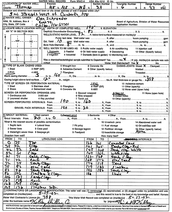
Specific Water Well Detail |
|
|
| Location Info | |||
| Owner: Schroeder, Dan | Status: Constructed | ||
| Location: T6S, R33W, Sec. 29, NE NE NE | County: Thomas | ||
| Directions: from Cumberlin: 5 mi W | |||
| Latitude: 39.5094307 | Longitude: -101.0181868 | Datum NAD 27 | |
| Latitude: 39.5094334 | Longitude: -101.0186198 | Datum NAD 83 | |
| Longitude and latitude calculated by Survey from township-range-section-quarter calls. Only good to within the quarter call accuracy. | |||
| View well on interactive map | |||
| General Info | ||
| Well Depth: 190 ft. | Elevation: ft. | |
| Static Water Level: 92 ft. | Est. Yield: 10 gpm. | |
| Comp. Date: 15-May-2002 | Well Use: Domestic | |
| DWR Applic. #: | Other ID: | |
| Driller Info | ||
| Driller: Richard O. Kelley Drilling Co. | License #: 398 | |
| Scanned Form | View scan |
|
Chemical Sample Submitted?:
Water Well disinfected?: | ||
| Casing Info | ||
| Casing Type:
Casing Joints: |
Diam: in. to ft | |
| Casing height above land surface: in
Casing Weight: lbs/ft Wall thickness or gauge no.: | ||
| Screen and Perforation Info | ||
| Screen Type: | Screen Openings: | |
| Screen-perforated intervals | From: ft to ft | |
| Gravel pack intervals | From: ft to ft | |
| Grout Info | ||
| Grout used: | From: to ft | |
| Source of Possible Contamination | ||
| Source: | ||
| Direction from well: | Distance: ft | |
| Lithologic Log
(Log data entered by KGS.) | ||
| From: 0 ft. to 35 ft. | Top | |
| From: 35 ft. to 42 ft. | Clay | |
| From: 42 ft. to 52 ft. | Sand | |
| From: 52 ft. to 61 ft. | Clay | |
| From: 61 ft. to 71 ft. | Sandy clay | |
| From: 71 ft. to 72 ft. | Rock | |
| From: 72 ft. to 75 ft. | Sandy clay | |
| From: 75 ft. to 93 ft. | Fine sand | |
| From: 93 ft. to 96 ft. | Sandy clay | |
| From: 96 ft. to 106 ft. | Limestone and clay | |
| From: 106 ft. to 127 ft. | Sandy clay | |
| From: 127 ft. to 128 ft. | Rock | |
| From: 128 ft. to 129 ft. | Clay | |
| From: 129 ft. to 136 ft. | Limestone soft | |
| From: 136 ft. to 141 ft. | Cemented sand | |
| From: 141 ft. to 145 ft. | Sandy clay - red | |
| From: 145 ft. to 149 ft. | Sandy clay white | |
| From: 149 ft. to 162 ft. | White clay | |
| From: 162 ft. to 168 ft. | Sandy clay | |
| From: 168 ft. to 174 ft. | Fine sand | |
| From: 174 ft. to 179 ft. | Sand | |
| From: 179 ft. to 180 ft. | Limestone | |
| From: 180 ft. to 186 ft. | Sandy clay | |
| From: 186 ft. to ft. | Shale | |