|
|
|
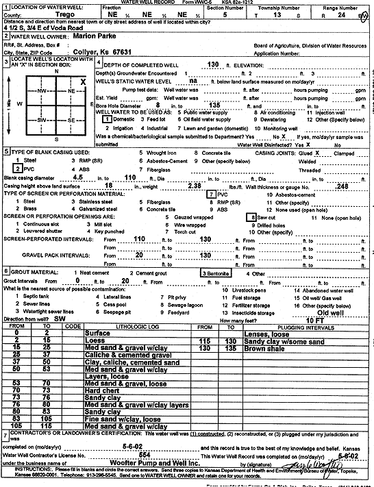
Specific Water Well Detail |
|
|
| Location Info | |||
| Owner: Parke, Marion | Status: Constructed | ||
| Location: T13S, R24W, Sec. 5, NE NE NE | County: Trego | ||
| Directions: from Voda Rd: 4.5 mi S, .75 mi E | |||
| Latitude: 38.9567967 | Longitude: -100.0028163 | Datum NAD 27 | |
| Latitude: 38.9568057 | Longitude: -100.0032187 | Datum NAD 83 | |
| Longitude and latitude calculated by Survey from township-range-section-quarter calls. Only good to within the quarter call accuracy. | |||
| View well on interactive map | |||
| General Info | ||
| Well Depth: 130 ft. | Elevation: ft. | |
| Static Water Level: ft. | Est. Yield: gpm. | |
| Comp. Date: 06-May-2002 | Well Use: Domestic | |
| DWR Applic. #: | Other ID: | |
| Links | |
| View info from Wizard Water Level Data base... | |
| No WIMAS information available. | |
| Driller Info | ||
| Driller: Jay C. Woofter Pump & Well, Inc. | License #: 554 | |
| Scanned Form | View scan |
|
Chemical Sample Submitted?:
Water Well disinfected?: | ||
| Casing Info | ||
| Casing Type:
Casing Joints: |
Diam: in. to ft | |
| Casing height above land surface: in
Casing Weight: lbs/ft Wall thickness or gauge no.: | ||
| Screen and Perforation Info | ||
| Screen Type: | Screen Openings: | |
| Screen-perforated intervals | From: ft to ft | |
| Gravel pack intervals | From: ft to ft | |
| Grout Info | ||
| Grout used: | From: to ft | |
| Source of Possible Contamination | ||
| Source: | ||
| Direction from well: | Distance: ft | |
| Lithologic Log
(Log data entered by KGS.) | ||
| From: 0 ft. to 2 ft. | surface | |
| From: 2 ft. to 15 ft. | loess | |
| From: 15 ft. to 25 ft. | medium sand and gravel with clay | |
| From: 25 ft. to 37 ft. | caliche and cemented gravel | |
| From: 37 ft. to 50 ft. | clay, caliche, cemented sand | |
| From: 50 ft. to 53 ft. | medium sand and gravel with clay layers, loose | |
| From: 53 ft. to 70 ft. | medium sand and gravel, loose | |
| From: 70 ft. to 73 ft. | hard chert | |
| From: 73 ft. to 76 ft. | sandy clay | |
| From: 76 ft. to 80 ft. | medium sand and gravel with clay layers | |
| From: 80 ft. to 83 ft. | sandy clay | |
| From: 83 ft. to 105 ft. | fine sand with clay, loose | |
| From: 105 ft. to 115 ft. | medium sand and gravel with clay lens, loose | |
| From: 115 ft. to 130 ft. | sandy clay with some sand | |
| From: 130 ft. to 135 ft. | brown shale | |