|
|
|
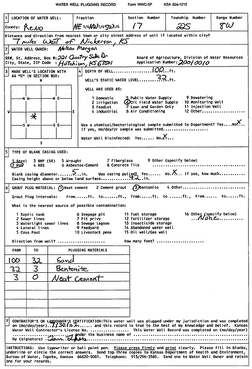
Specific Water Well Detail |
|
|
| Location Info | |||
| Owner: Morgan, Nelson | Status: Plugged | ||
| Location: T22S, R8W, Sec. 17, NE NW SW | County: Reno | ||
| Directions: from Nickerson: 7 mi W | |||
| Latitude: 38.1358424 | Longitude: -98.2306774 | Datum NAD 27 | |
| Latitude: 38.1358543 | Longitude: -98.2310183 | Datum NAD 83 | |
| Longitude and latitude calculated by Survey from township-range-section-quarter calls. Only good to within the quarter call accuracy. | |||
| View well on interactive map | |||
| General Info | ||
| Well Depth: 100 ft. | Elevation: ft. | |
| Static Water Level: 32 ft. | Est. Yield: gpm. | |
| Comp. Date: 30-Jul-2002 | Well Use: Oil Field Water Supply | |
| DWR Applic. #: 20010010 | Other ID: | |
| Links | |
| No Wizard information available. | |
| View info from WIMAS Water Right Data base... | |
| Driller Info | ||
| Driller: Tom Theis | License #: | |
| Scanned Form | View scan |
| Casing Info | ||
|
Casing Type:
Diam: in. Casing height above land surface: in | ||
| Grout Info | ||
| Grout used: | From: to ft | |
| Source of Possible Contamination | ||
| Source: | ||
| Direction from well: | Distance: ft | |