|
|
|
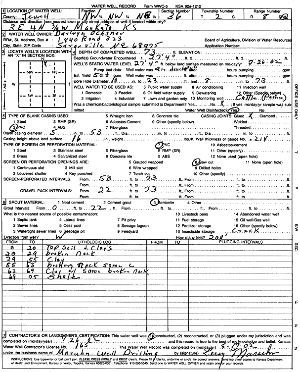
Specific Water Well Detail |
|
|
| Location Info | |||
| Owner: Ochsner, Darwyn | Status: Constructed | ||
| Location: T2S, R8W, Sec. 36, NW NW NE | County: Jewell | ||
| Directions: from Mankato: 3 mi E, 4 mi N, .38 mi W | |||
| Latitude: 39.8417512 | Longitude: -98.1642973 | Datum NAD 27 | |
| Latitude: 39.8417635 | Longitude: -98.164624 | Datum NAD 83 | |
| Longitude and latitude calculated by Survey from township-range-section-quarter calls. Only good to within the quarter call accuracy. | |||
| View well on interactive map | |||
| General Info | ||
| Well Depth: 73 ft. | Elevation: ft. | |
| Static Water Level: 27.33 ft. | Est. Yield: 50 gpm. | |
| Comp. Date: 26-Jul-2002 | Well Use: Domestic, Livestock | |
| DWR Applic. #: | Other ID: | |
| Driller Info | ||
| Driller: Leroy Maruhn Well Drilling, Inc. | License #: 165 | |
| Scanned Form | View scan |
|
Chemical Sample Submitted?:
Water Well disinfected?: | ||
| Casing Info | ||
| Casing Type:
Casing Joints: |
Diam: in. to ft | |
| Casing height above land surface: in
Casing Weight: lbs/ft Wall thickness or gauge no.: | ||
| Screen and Perforation Info | ||
| Screen Type: | Screen Openings: | |
| Screen-perforated intervals | From: ft to ft | |
| Gravel pack intervals | From: ft to ft | |
| Grout Info | ||
| Grout used: | From: to ft | |
| Source of Possible Contamination | ||
| Source: | ||
| Direction from well: | Distance: ft | |
| Lithologic Log
(Log data entered by KGS.) | ||
| From: 0 ft. to 20 ft. | top soil and clays | |
| From: 20 ft. to 29 ft. | broken rock | |
| From: 29 ft. to 55 ft. | clay | |
| From: 55 ft. to 63 ft. | broken rock, some clay | |
| From: 63 ft. to 69 ft. | clay with some broken rock | |
| From: 69 ft. to 75 ft. | shale | |