|
|
|
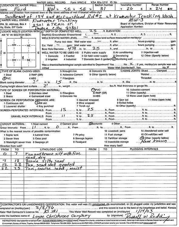
Specific Water Well Detail |
|
|
| Location Info | |||
| Owner: Kindsvater Trucking | Status: Constructed | ||
| Location: T26S, R24W, Sec. 31, NW SE SE | County: Ford | ||
| Directions: from 154 and McCaustland Rd 2: SE, at Kindsvater Truck Wash | |||
| Latitude: 37.7388472 | Longitude: -99.981582 | Datum NAD 27 | |
| Latitude: 37.7388675 | Longitude: -99.9819931 | Datum NAD 83 | |
| Longitude and latitude calculated by Survey from township-range-section-quarter calls. Only good to within the quarter call accuracy. | |||
| View well on interactive map | |||
| General Info | ||
| Well Depth: 25 ft. | Elevation: ft. | |
| Static Water Level: ft. | Est. Yield: gpm. | |
| Comp. Date: 08-Feb-1996 | Well Use: Monitoring well/observation/piezometer | |
| DWR Applic. #: | Other ID: MW 3 | |
| Driller Info | ||
| Driller: Layne Western | License #: 581 | |
| Scanned Form | View scan |
|
Chemical Sample Submitted?:
Water Well disinfected?: | ||
| Casing Info | ||
| Casing Type:
Casing Joints: |
Diam: in. to ft | |
| Casing height above land surface: in
Casing Weight: lbs/ft Wall thickness or gauge no.: | ||
| Screen and Perforation Info | ||
| Screen Type: | Screen Openings: | |
| Screen-perforated intervals | From: ft to ft | |
| Gravel pack intervals | From: ft to ft | |
| Grout Info | ||
| Grout used: | From: to ft | |
| Source of Possible Contamination | ||
| Source: | ||
| Direction from well: | Distance: ft | |
| Lithologic Log
(Log data entered by KGS.) | ||
| From: 0 ft. to 7 ft. | tan and brown silt with fine sand, dry | |
| From: 7 ft. to 12 ft. | brown silty sand | |
| From: 12 ft. to 22 ft. | tan, sand well graded | |
| From: 22 ft. to 25 ft. | tan, coarse sand, moist | |