|
|
|
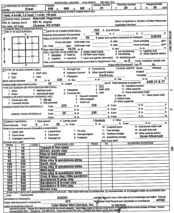
Specific Water Well Detail |
|
|
| Location Info | |||
| Owner: Hagerman, Kenneth | Status: Constructed | ||
| Location: T29S, R36W, Sec. 21, NW NW NE | County: Grant | ||
| Directions: from Ulysses: 7 mi E, 4 mi S, 1.5 mi W, 1 mi N, and 0.13 mi E | |||
| Latitude: 37.5174355 | Longitude: -101.2608093 | Datum NAD 27 | |
| Latitude: 37.5174584 | Longitude: -101.2612564 | Datum NAD 83 | |
| Longitude and latitude calculated by Survey from township-range-section-quarter calls. Only good to within the quarter call accuracy. | |||
| View well on interactive map | |||
| General Info | ||
| Well Depth: 335 ft. | Elevation: ft. | |
| Static Water Level: 95 ft. | Est. Yield: gpm. | |
| Comp. Date: 25-Mar-2002 | Well Use: Domestic | |
| DWR Applic. #: | Other ID: | |
| Driller Info | ||
| Driller: Destal Tyler Water Well Service | License #: 473 | |
| Scanned Form | View scan |
|
Chemical Sample Submitted?:
Water Well disinfected?: | ||
| Casing Info | ||
| Casing Type:
Casing Joints: |
Diam: in. to ft | |
| Casing height above land surface: in
Casing Weight: lbs/ft Wall thickness or gauge no.: | ||
| Screen and Perforation Info | ||
| Screen Type: | Screen Openings: | |
| Screen-perforated intervals | From: ft to ft | |
| Gravel pack intervals | From: ft to ft | |
| Grout Info | ||
| Grout used: | From: to ft | |
| Source of Possible Contamination | ||
| Source: | ||
| Direction from well: | Distance: ft | |
| Lithologic Log
(Log data entered by KGS.) | ||
| From: 0 ft. to 15 ft. | Topsoil and fine sand | |
| From: 15 ft. to 55 ft. | Brown, sandy clay | |
| From: 55 ft. to 70 ft. | Fine to medium sand | |
| From: 70 ft. to 95 ft. | Brown clay | |
| From: 95 ft. to 120 ft. | Gray clay and sandstone streaks | |
| From: 120 ft. to 125 ft. | Sand, med. | |
| From: 125 ft. to 131 ft. | Gray clay and sandstone streaks | |
| From: 131 ft. to 135 ft. | Med sand | |
| From: 135 ft. to 195 ft. | Gray clay and sandstone streaks | |
| From: 195 ft. to 235 ft. | Gray and blue clay; little sandstone | |
| From: 235 ft. to 275 ft. | Sandstone and gray clay | |
| From: 275 ft. to 305 ft. | Sandstone and brown clay | |
| From: 305 ft. to 325 ft. | Sandstone and little clay | |
| From: 325 ft. to 335 ft. | Brown clay | |