|
|
|
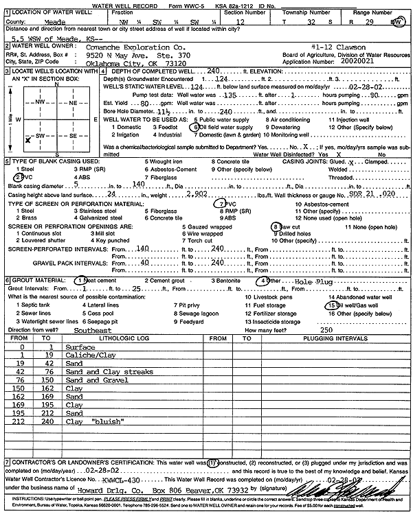
Specific Water Well Detail |
|
|
| Location Info | |||
| Owner: Comanche Exploration Co | Status: Constructed | ||
| Location: T32S, R29W, Sec. 12, NW SW SW | County: Meade | ||
| Directions: from Meade: 5.5 mi WSW (1-12 Clawson) | |||
| Latitude: 37.2737601 | Longitude: -100.4335095 | Datum NAD 27 | |
| Latitude: 37.2737834 | Longitude: -100.4339357 | Datum NAD 83 | |
| Longitude and latitude calculated by Survey from township-range-section-quarter calls. Only good to within the quarter call accuracy. | |||
| View well on interactive map | |||
| General Info | ||
| Well Depth: 240 ft. | Elevation: ft. | |
| Static Water Level: 124 ft. | Est. Yield: 80 gpm. | |
| Comp. Date: 28-Feb-2002 | Well Use: Oil Field Water Supply | |
| DWR Applic. #: 20020021 | Other ID: 1-12 Clawson | |
| Links | |
| No Wizard information available. | |
| View info from WIMAS Water Right Data base... | |
| Driller Info | ||
| Driller: Howard Drilling Company AG, LLC | License #: 430 | |
| Scanned Form | View scan |
|
Chemical Sample Submitted?:
Water Well disinfected?: | ||
| Casing Info | ||
| Casing Type:
Casing Joints: |
Diam: in. to ft | |
| Casing height above land surface: in
Casing Weight: lbs/ft Wall thickness or gauge no.: | ||
| Screen and Perforation Info | ||
| Screen Type: | Screen Openings: | |
| Screen-perforated intervals | From: ft to ft | |
| Gravel pack intervals | From: ft to ft | |
| Grout Info | ||
| Grout used: | From: to ft | |
| Source of Possible Contamination | ||
| Source: | ||
| Direction from well: | Distance: ft | |
| Lithologic Log
(Log data entered by KGS.) | ||
| From: 0 ft. to 1 ft. | surface | |
| From: 1 ft. to 19 ft. | caliche and clay | |
| From: 19 ft. to 42 ft. | sand | |
| From: 42 ft. to 76 ft. | sand and clay streaks | |
| From: 76 ft. to 150 ft. | sand and gravel | |
| From: 150 ft. to 162 ft. | clay | |
| From: 162 ft. to 169 ft. | sand | |
| From: 169 ft. to 195 ft. | clay | |
| From: 195 ft. to 212 ft. | sand | |
| From: 212 ft. to 240 ft. | clay, bluish | |