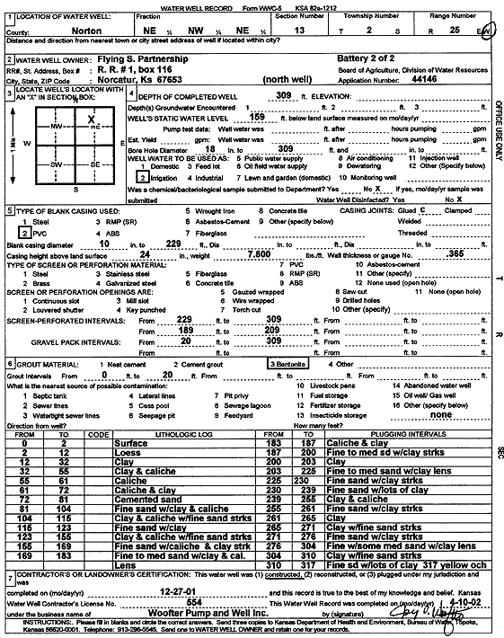
Lithologic Log
(Log data entered by KGS.) |
| |
From: 0 ft. to 2 ft. |
surface |
| |
From: 2 ft. to 12 ft. |
loess |
| |
From: 12 ft. to 32 ft. |
clay |
| |
From: 32 ft. to 55 ft. |
clay and caliche |
| |
From: 55 ft. to 61 ft. |
caliche |
| |
From: 61 ft. to 72 ft. |
caliche and clay |
| |
From: 72 ft. to 81 ft. |
cemented sand |
| |
From: 81 ft. to 104 ft. |
fine sand with clay and caliche |
| |
From: 104 ft. to 115 ft. |
clay and caliche with fine sand streaks |
| |
From: 115 ft. to 123 ft. |
fine sand with clay |
| |
From: 123 ft. to 155 ft. |
clay and caliche with fine sand streaks |
| |
From: 155 ft. to 169 ft. |
fine sand with caliche and clay streak |
| |
From: 169 ft. to 183 ft. |
fine to medium sand with clay and caliche lens |
| |
From: 183 ft. to 187 ft. |
caliche and clay |
| |
From: 187 ft. to 200 ft. |
fine to medium sand with clay streak |
| |
From: 200 ft. to 203 ft. |
clay |
| |
From: 203 ft. to 225 ft. |
fine to medium sand with clay lens |
| |
From: 225 ft. to 230 ft. |
fine sand with clay streak |
| |
From: 230 ft. to 239 ft. |
fine sand with lots of clay |
| |
From: 239 ft. to 255 ft. |
clay and caliche |
| |
From: 255 ft. to 261 ft. |
fine sand with clay streaks |
| |
From: 261 ft. to 265 ft. |
clay |
| |
From: 265 ft. to 271 ft. |
clay with fine sand streaks |
| |
From: 271 ft. to 276 ft. |
fine sand with clay streaks |
| |
From: 276 ft. to 304 ft. |
fine with some medium sand with clay lens |
| |
From: 304 ft. to 310 ft. |
clay with fine sand streaks |
| |
From: 310 ft. to 317 ft. |
fine sand with lots of clay |
| |
From: 317 ft. to ft. |
yellow ochre |