|
|
|
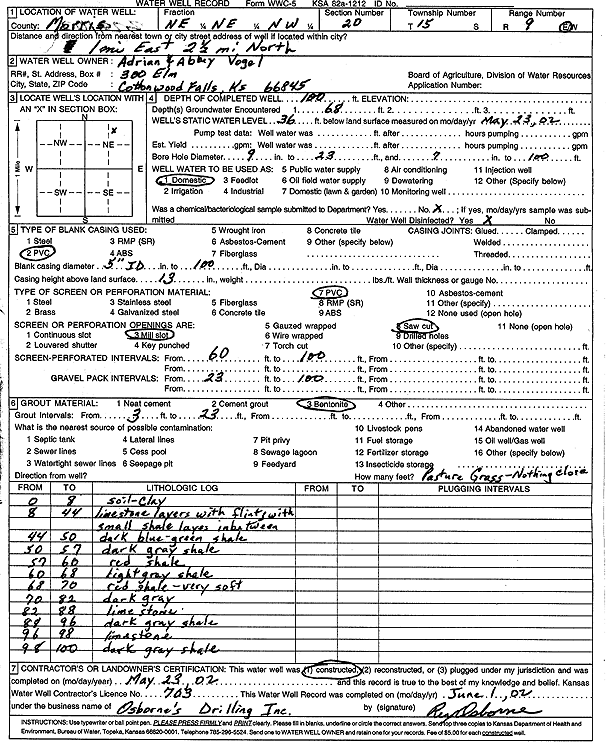
Specific Water Well Detail |
|
|
| Location Info | |||
| Owner: Vogel, Adrian and Abby | Status: Constructed | ||
| Location: T15S, R9E, Sec. 20, NE NE NW | County: Morris | ||
| Directions: 1 mi E, 2.5 mi N | |||
| Latitude: 38.7380266 | Longitude: -96.4368631 | Datum NAD 27 | |
| Latitude: 38.7380322 | Longitude: -96.437142 | Datum NAD 83 | |
| Longitude and latitude calculated by Survey from township-range-section-quarter calls. Only good to within the quarter call accuracy. | |||
| View well on interactive map | |||
| General Info | ||
| Well Depth: 100 ft. | Elevation: ft. | |
| Static Water Level: 36 ft. | Est. Yield: gpm. | |
| Comp. Date: 23-May-2002 | Well Use: Domestic | |
| DWR Applic. #: | Other ID: | |
| Driller Info | ||
| Driller: Osborne's Drilling, Inc. | License #: 703 | |
| Scanned Form | View scan |
|
Chemical Sample Submitted?:
Water Well disinfected?: | ||
| Casing Info | ||
| Casing Type:
Casing Joints: |
Diam: in. to ft | |
| Casing height above land surface: in
Casing Weight: lbs/ft Wall thickness or gauge no.: | ||
| Screen and Perforation Info | ||
| Screen Type: | Screen Openings: | |
| Screen-perforated intervals | From: ft to ft | |
| Gravel pack intervals | From: ft to ft | |
| Grout Info | ||
| Grout used: | From: to ft | |
| Source of Possible Contamination | ||
| Source: | ||
| Direction from well: | Distance: ft | |
| Lithologic Log
(Log data entered by KGS.) | ||
| From: 0 ft. to 8 ft. | soil and clay | |
| From: 8 ft. to 44 ft. | limestone layers with flint, small shale layers in between | |
| From: 44 ft. to 50 ft. | dark blue-green shale | |
| From: 50 ft. to 57 ft. | dark gray shale | |
| From: 57 ft. to 60 ft. | red shale | |
| From: 60 ft. to 68 ft. | light gray shale | |
| From: 68 ft. to 70 ft. | red shale, very soft | |
| From: 70 ft. to 82 ft. | dark gray shale | |
| From: 82 ft. to 88 ft. | limestone | |
| From: 88 ft. to 96 ft. | dark gray shale | |
| From: 96 ft. to 98 ft. | limestone | |
| From: 98 ft. to 100 ft. | dark gray shale | |