|
|
|
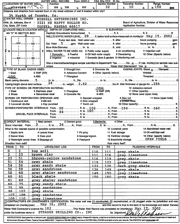
Specific Water Well Detail |
|
|
| Location Info | |||
| Owner: Russell Enterprises, Inc. | Status: Constructed | ||
| Location: T10S, R15E, Sec. 32, SE NE SE | County: Shawnee | ||
| Directions: from Topeka: 3.5 mi N | |||
| Latitude: 39.1339703 | Longitude: -95.7576689 | Datum NAD 27 | |
| Latitude: 39.1339692 | Longitude: -95.7579305 | Datum NAD 83 | |
| Longitude and latitude calculated by Survey from township-range-section-quarter calls. Only good to within the quarter call accuracy. | |||
| View well on interactive map | |||
| General Info | ||
| Well Depth: ft. | Elevation: ft. | |
| Static Water Level: 29 ft. | Est. Yield: 5 gpm. | |
| Comp. Date: 16-May-2002 | Well Use: Domestic | |
| DWR Applic. #: | Other ID: | |
| Driller Info | ||
| Driller: Strader Drilling Co., Inc. | License #: 182 | |
| Scanned Form | View scan |
|
Chemical Sample Submitted?:
Water Well disinfected?: | ||
| Casing Info | ||
| Casing Type:
Casing Joints: |
Diam: in. to ft | |
| Casing height above land surface: in
Casing Weight: lbs/ft Wall thickness or gauge no.: | ||
| Screen and Perforation Info | ||
| Screen Type: | Screen Openings: | |
| Screen-perforated intervals | From: ft to ft | |
| Gravel pack intervals | From: ft to ft | |
| Grout Info | ||
| Grout used: | From: to ft | |
| Source of Possible Contamination | ||
| Source: | ||
| Direction from well: | Distance: ft | |
| Lithologic Log
(Log data entered by KGS.) | ||
| From: 0 ft. to 2 ft. | top soil | |
| From: 2 ft. to 23 ft. | brown clay | |
| From: 23 ft. to 51 ft. | brown-yellow sandstone | |
| From: 51 ft. to 54 ft. | gray shale | |
| From: 54 ft. to 56 ft. | gray sandy shale | |
| From: 56 ft. to 58 ft. | gray sandstone | |
| From: 58 ft. to 60 ft. | gray shaley sandstone | |
| From: 60 ft. to 61 ft. | black shale | |
| From: 61 ft. to 68 ft. | gray shaley sandstone | |
| From: 68 ft. to 75 ft. | gray sandy shale | |
| From: 75 ft. to 98 ft. | gray sandstone | |
| From: 98 ft. to 107 ft. | gray shale | |
| From: 107 ft. to 109 ft. | gray sandstone | |
| From: 109 ft. to 110 ft. | gray limestone | |
| From: 110 ft. to 111 ft. | gray shale | |
| From: 111 ft. to 116 ft. | gray limestone | |
| From: 116 ft. to 119 ft. | gray shale | |
| From: 119 ft. to 122 ft. | gray limestone | |
| From: 122 ft. to 126 ft. | dark gray shale | |
| From: 126 ft. to 149 ft. | gray shale | |
| From: 149 ft. to 150 ft. | gray limestone | |
| From: 150 ft. to 160 ft. | gray shale | |