|
|
|
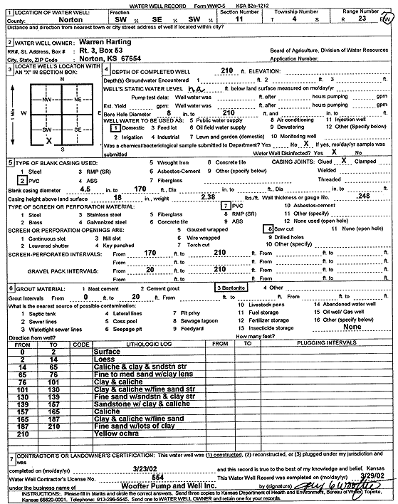
Specific Water Well Detail |
|
|
| Location Info | |||
| Owner: Harting, Warren | Status: Constructed | ||
| Location: T4S, R23W, Sec. 11, SW SE SW | County: Norton | ||
| Directions: | |||
| Latitude: 39.7127341 | Longitude: -99.8835052 | Datum NAD 27 | |
| Latitude: 39.7127394 | Longitude: -99.883905 | Datum NAD 83 | |
| Longitude and latitude calculated by Survey from township-range-section-quarter calls. Only good to within the quarter call accuracy. | |||
| View well on interactive map | |||
| General Info | ||
| Well Depth: 210 ft. | Elevation: ft. | |
| Static Water Level: ft. | Est. Yield: gpm. | |
| Comp. Date: 23-Mar-2002 | Well Use: Domestic | |
| DWR Applic. #: | Other ID: | |
| Driller Info | ||
| Driller: Jay C. Woofter Pump & Well, Inc. | License #: 554 | |
| Scanned Form | View scan |
|
Chemical Sample Submitted?:
Water Well disinfected?: | ||
| Casing Info | ||
| Casing Type:
Casing Joints: |
Diam: in. to ft | |
| Casing height above land surface: in
Casing Weight: lbs/ft Wall thickness or gauge no.: | ||
| Screen and Perforation Info | ||
| Screen Type: | Screen Openings: | |
| Screen-perforated intervals | From: ft to ft | |
| Gravel pack intervals | From: ft to ft | |
| Grout Info | ||
| Grout used: | From: to ft | |
| Source of Possible Contamination | ||
| Source: | ||
| Direction from well: | Distance: ft | |
| Lithologic Log
(Log data entered by KGS.) | ||
| From: 0 ft. to 2 ft. | surface | |
| From: 2 ft. to 14 ft. | loess | |
| From: 14 ft. to 65 ft. | caliche and clay and sandstone streak | |
| From: 65 ft. to 76 ft. | fine to medium sand with clay lens | |
| From: 76 ft. to 101 ft. | clay and caliche | |
| From: 101 ft. to 130 ft. | clay and caliche with fine sand streak | |
| From: 130 ft. to 139 ft. | fine sand with sandstone and clay streak | |
| From: 139 ft. to 157 ft. | sandstone with clay and caliche | |
| From: 157 ft. to 165 ft. | caliche | |
| From: 165 ft. to 187 ft. | clay and caliche with fine sand | |
| From: 187 ft. to 210 ft. | fine sand with lots of clay | |
| From: 210 ft. to ft. | yellow ochre | |