|
|
|
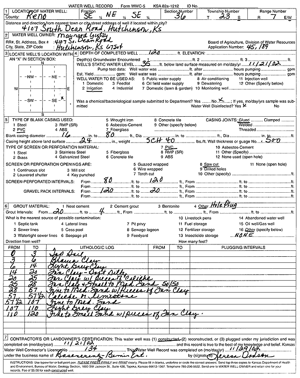
Specific Water Well Detail |
|
|
| Location Info | |||
| Owner: Yutzy, Maynard | Status: Constructed | ||
| Location: T23S, R7W, Sec. 36, SE NE SE | County: Reno | ||
| Directions: 4107 S Dean Rd, Hutchinson | |||
| Latitude: 38.0035772 | Longitude: -98.0326996 | Datum NAD 27 | |
| Latitude: 38.0035892 | Longitude: -98.033033 | Datum NAD 83 | |
| Longitude and latitude calculated by Survey from township-range-section-quarter calls. Only good to within the quarter call accuracy. | |||
| View well on interactive map | |||
| General Info | ||
| Well Depth: 120 ft. | Elevation: ft. | |
| Static Water Level: 35 ft. | Est. Yield: gpm. | |
| Comp. Date: 21-Nov-2002 | Well Use: Irrigation | |
| DWR Applic. #: 45189 | Other ID: | |
| Links | |
| No Wizard information available. | |
| View info from WIMAS Water Right Data base... | |
| Driller Info | ||
| Driller: Rosencrantz-Bemis Enterprises, Inc. | License #: 134 | |
| Scanned Form | View scan |
|
Chemical Sample Submitted?:
Water Well disinfected?: | ||
| Casing Info | ||
| Casing Type:
Casing Joints: |
Diam: in. to ft | |
| Casing height above land surface: in
Casing Weight: lbs/ft Wall thickness or gauge no.: | ||
| Screen and Perforation Info | ||
| Screen Type: | Screen Openings: | |
| Screen-perforated intervals | From: ft to ft | |
| Gravel pack intervals | From: ft to ft | |
| Grout Info | ||
| Grout used: | From: to ft | |
| Source of Possible Contamination | ||
| Source: | ||
| Direction from well: | Distance: ft | |
| Lithologic Log
(Log data entered by KGS.) | ||
| From: 0 ft. to 3 ft. | top soil | |
| From: 3 ft. to 6 ft. | brown clay | |
| From: 6 ft. to 14 ft. | light gray clay | |
| From: 14 ft. to 20 ft. | tan clay, soft, silty | |
| From: 20 ft. to 25 ft. | tan clay with pieces of caliche | |
| From: 25 ft. to 28 ft. | tan clay and small to medium sand (50/50) | |
| From: 28 ft. to 57 ft. | fine to medium sand with pieces of tan clay | |
| From: 57 ft. to 57.5 ft. | caliche or limestone | |
| From: 57.5 ft. to 107 ft. | fine to medium sand | |
| From: 107 ft. to 110 ft. | light gray clay | |
| From: 110 ft. to 120 ft. | fine to small sand with pieces of tan clay | |