|
|
|
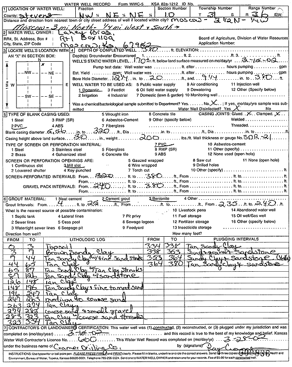
Specific Water Well Detail |
|
|
| Location Info | |||
| Owner: Lahey Bros. | Status: Constructed | ||
| Location: T31S, R36W, Sec. 10, NW NE NE | County: Stevens | ||
| Directions: from Moscow, 3 mi N, 0.25 mi W, and S to site | |||
| Latitude: 37.3723405 | Longitude: -101.2159124 | Datum NAD 27 | |
| Latitude: 37.3723643 | Longitude: -101.2163531 | Datum NAD 83 | |
| Longitude and latitude calculated by Survey from township-range-section-quarter calls. Only good to within the quarter call accuracy. | |||
| View well on interactive map | |||
| General Info | ||
| Well Depth: 380 ft. | Elevation: ft. | |
| Static Water Level: 170 ft. | Est. Yield: gpm. | |
| Comp. Date: 15-Mar-2002 | Well Use: Domestic | |
| DWR Applic. #: | Other ID: | |
| Driller Info | ||
| Driller: Ray Cramer Drilling Co. | License #: 600 | |
| Scanned Form | View scan |
|
Chemical Sample Submitted?:
Water Well disinfected?: | ||
| Casing Info | ||
| Casing Type:
Casing Joints: |
Diam: in. to ft | |
| Casing height above land surface: in
Casing Weight: lbs/ft Wall thickness or gauge no.: | ||
| Screen and Perforation Info | ||
| Screen Type: | Screen Openings: | |
| Screen-perforated intervals | From: ft to ft | |
| Gravel pack intervals | From: ft to ft | |
| Grout Info | ||
| Grout used: | From: to ft | |
| Source of Possible Contamination | ||
| Source: | ||
| Direction from well: | Distance: ft | |
| Lithologic Log
(Log data entered by KGS.) | ||
| From: 0 ft. to 3 ft. | topsoil | |
| From: 3 ft. to 7 ft. | brown sandy clay | |
| From: 7 ft. to 44 ft. | tan sandy clay with fine sand streaks | |
| From: 44 ft. to 65 ft. | tan clay | |
| From: 65 ft. to 87 ft. | tan sandy clay with tan clay streaks | |
| From: 87 ft. to 126 ft. | tan sandy clay with sandstone | |
| From: 126 ft. to 148 ft. | tan clay | |
| From: 148 ft. to 196 ft. | tan sandy clay and fine to medium sand | |
| From: 196 ft. to 247 ft. | tan clay | |
| From: 247 ft. to 263 ft. | medium to coarse sand | |
| From: 263 ft. to 274 ft. | tan clay | |
| From: 274 ft. to 283 ft. | coarse sand and small gravel | |
| From: 283 ft. to 323 ft. | tan clay with coarse sand streaks | |
| From: 323 ft. to 334 ft. | tan clay | |
| From: 334 ft. to 338 ft. | tan sandy clay | |
| From: 338 ft. to 353 ft. | sand and gravel and sandstone | |
| From: 353 ft. to 364 ft. | sandy clay and sandstone (yellow) | |
| From: 364 ft. to 380 ft. | tan sandy clay and sandstone | |