|
|
|
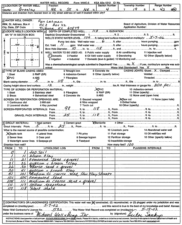
Specific Water Well Detail |
|
|
| Location Info | |||
| Owner: Lehman, Ron | Status: Constructed | ||
| Location: T19S, R42W, Sec. 4, NE SE NE | County: Greeley | ||
| Directions: | |||
| Latitude: 38.4319263 | Longitude: -101.9564111 | Datum NAD 27 | |
| Latitude: 38.4319424 | Longitude: -101.9568672 | Datum NAD 83 | |
| Longitude and latitude calculated by Survey from township-range-section-quarter calls. Only good to within the quarter call accuracy. | |||
| View well on interactive map | |||
| General Info | ||
| Well Depth: 118 ft. | Elevation: ft. | |
| Static Water Level: 104 ft. | Est. Yield: 11 gpm. | |
| Comp. Date: 07-May-2002 | Well Use: Domestic | |
| DWR Applic. #: | Other ID: | |
| Driller Info | ||
| Driller: Midwest Well & Pump, Inc. | License #: 532 | |
| Scanned Form | View scan |
|
Chemical Sample Submitted?:
Water Well disinfected?: | ||
| Casing Info | ||
| Casing Type:
Casing Joints: |
Diam: in. to ft | |
| Casing height above land surface: in
Casing Weight: lbs/ft Wall thickness or gauge no.: | ||
| Screen and Perforation Info | ||
| Screen Type: | Screen Openings: | |
| Screen-perforated intervals | From: ft to ft | |
| Gravel pack intervals | From: ft to ft | |
| Grout Info | ||
| Grout used: | From: to ft | |
| Source of Possible Contamination | ||
| Source: | ||
| Direction from well: | Distance: ft | |
| Lithologic Log
(Log data entered by KGS.) | ||
| From: 0 ft. to 1 ft. | Top soil | |
| From: 1 ft. to 11 ft. | Brown clay | |
| From: 11 ft. to 21 ft. | Cemented sand and gravel | |
| From: 21 ft. to 26 ft. | Gypsum and brown clay | |
| From: 26 ft. to 30 ft. | Coarse sand and gravel | |
| From: 30 ft. to 41 ft. | Gypsum and brown clay | |
| From: 41 ft. to 101 ft. | Medium to coarse sand, few clay streaks | |
| From: 101 ft. to 105 ft. | Cemented sand | |
| From: 105 ft. to 111 ft. | Medium to coarse sand and gravel | |
| From: 111 ft. to 117 ft. | Yellow soapstone | |
| From: 117 ft. to 118 ft. | Black shale | |