|
|
|
Specific Water Well Detail |
|
|
| Location Info | |||
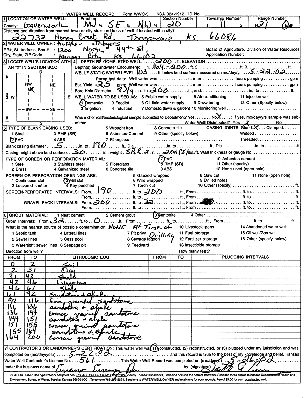
| Owner: Byers, Auther J. | Status: Constructed | ||
| Location: T11S, R21E, Sec. 20, NW SE NW | County: Leavenworth | ||
| Directions: 22732 Honey Creek Rd, Tonganoxie | |||
| Latitude: 39.0830017 | Longitude: -95.1061351 | Datum NAD 27 | |
| Latitude: 39.0830036 | Longitude: -95.1063822 | Datum NAD 83 | |
| Longitude and latitude calculated by Survey from township-range-section-quarter calls. Only good to within the quarter call accuracy. | |||
| View well on interactive map | |||
| General Info | ||
| Well Depth: 200 ft. | Elevation: ft. | |
| Static Water Level: 103 ft. | Est. Yield: 25 gpm. | |
| Comp. Date: 22-May-2002 | Well Use: Domestic | |
| DWR Applic. #: | Other ID: | |
| Driller Info | ||
| Driller: Evans Energy Development, Inc. | License #: 561 | |
| Scanned Form | View scan |
|
Chemical Sample Submitted?:
Water Well disinfected?: | ||
| Casing Info | ||
| Casing Type:
Casing Joints: |
Diam: in. to ft | |
| Casing height above land surface: in
Casing Weight: lbs/ft Wall thickness or gauge no.: | ||
| Screen and Perforation Info | ||
| Screen Type: | Screen Openings: | |
| Screen-perforated intervals | From: ft to ft | |
| Gravel pack intervals | From: ft to ft | |
| Grout Info | ||
| Grout used: | From: to ft | |
| Source of Possible Contamination | ||
| Source: | ||
| Direction from well: | Distance: ft | |
| Lithologic Log
(Log data entered by KGS.) | ||
| From: 0 ft. to 2 ft. | soil | |
| From: 2 ft. to 31 ft. | clay | |
| From: 31 ft. to 42 ft. | shale | |
| From: 42 ft. to 46 ft. | limestone | |
| From: 46 ft. to 61 ft. | shale | |
| From: 61 ft. to 92 ft. | sandstone and shale | |
| From: 92 ft. to 116 ft. | fine sandstone | |
| From: 116 ft. to 136 ft. | sandstone and shale | |
| From: 136 ft. to 144 ft. | coarse sandstone | |
| From: 144 ft. to 151 ft. | sandstone and shale | |
| From: 151 ft. to 155 ft. | coarse sandstone | |
| From: 155 ft. to 164 ft. | sandstone and shale | |
| From: 164 ft. to 200 ft. | coarse sandstone | |