|
|
|
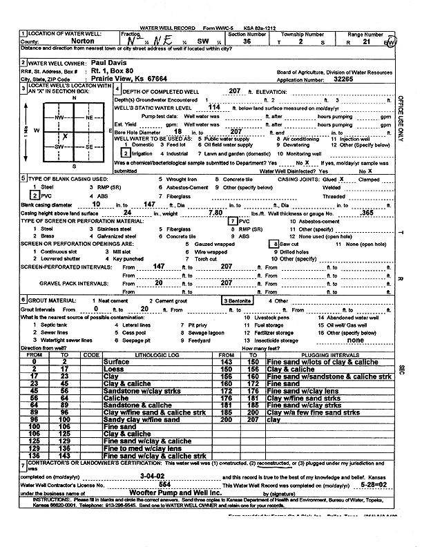
Specific Water Well Detail |
|
|
| Location Info | |||
| Owner: Davis, Paul | Status: Reconstructed | ||
| Location: T2S, R21W, Sec. 36, N2 NE SW | County: Norton | ||
| Directions: | |||
| Latitude: 39.8345238 | Longitude: -99.638478 | Datum NAD 27 | |
| Latitude: 39.8345315 | Longitude: -99.6388662 | Datum NAD 83 | |
| Longitude and latitude calculated by Survey from township-range-section-quarter calls. Only good to within the quarter call accuracy. | |||
| View well on interactive map | |||
| General Info | ||
| Well Depth: 207 ft. | Elevation: ft. | |
| Static Water Level: 114 ft. | Est. Yield: gpm. | |
| Comp. Date: 04-Mar-2002 | Well Use: Irrigation | |
| DWR Applic. #: 32265 | Other ID: | |
| Links | |
| View info from Wizard Water Level Data base... | |
| View info from WIMAS Water Right Data base... | |
| Driller Info | ||
| Driller: Jay C. Woofter Pump & Well, Inc. | License #: 554 | |
| Scanned Form | View scan |
|
Chemical Sample Submitted?: No
Water Well disinfected?: No | ||
| Bore hole diameter: 18 inches to 207 ft | ||
| Casing Info | ||
| Casing Type: PVC
Casing Joints: Glued |
Diam: 10 in. to 147 ft | |
| Casing height above land surface: 24 in
Casing Weight: 7.8 lbs/ft Wall thickness or gauge no.: .365 | ||
| Screen and Perforation Info | ||
| Screen Type: PVC | Screen Openings: Saw cut | |
| Screen-perforated intervals | From: 147 ft to 207 ft | |
| Gravel pack intervals | From: 20 ft to 207 ft | |
| Grout Info | ||
| Grout used: Bentonite | From: 0 to 20 ft | |
| Source of Possible Contamination | ||
| Source: none | ||
| Direction from well: | Distance: ft | |
| Lithologic Log
(Log data entered by KGS.) | ||
| From: 0 ft. to 2 ft. | surface | |
| From: 2 ft. to 17 ft. | loess | |
| From: 17 ft. to 23 ft. | clay | |
| From: 23 ft. to 45 ft. | clay and caliche | |
| From: 45 ft. to 56 ft. | sandstone with clay streaks | |
| From: 56 ft. to 64 ft. | caliche | |
| From: 64 ft. to 89 ft. | sandstone and caliche | |
| From: 89 ft. to 96 ft. | clay with fine sand and caliche streak | |
| From: 96 ft. to 100 ft. | sandy clay with fine sand | |
| From: 100 ft. to 105 ft. | fine sand | |
| From: 105 ft. to 125 ft. | clay and caliche | |
| From: 125 ft. to 129 ft. | fine sand with clay and caliche | |
| From: 129 ft. to 136 ft. | fine to medium sand with clay lens | |
| From: 136 ft. to 143 ft. | fine sand with clay and caliche streak | |
| From: 143 ft. to 150 ft. | fine sand with lots of clay and caliche | |
| From: 150 ft. to 156 ft. | clay and caliche | |
| From: 156 ft. to 160 ft. | fine sand with sandstone and caliche streaks | |
| From: 160 ft. to 172 ft. | fine sand | |
| From: 172 ft. to 176 ft. | fine sand with clay lens | |
| From: 176 ft. to 181 ft. | clay with fine sand streaks | |
| From: 181 ft. to 185 ft. | fine sand with clay streaks | |
| From: 185 ft. to 200 ft. | clay with a few fine sand streaks | |
| From: 200 ft. to 207 ft. | clay | |