|
|
|
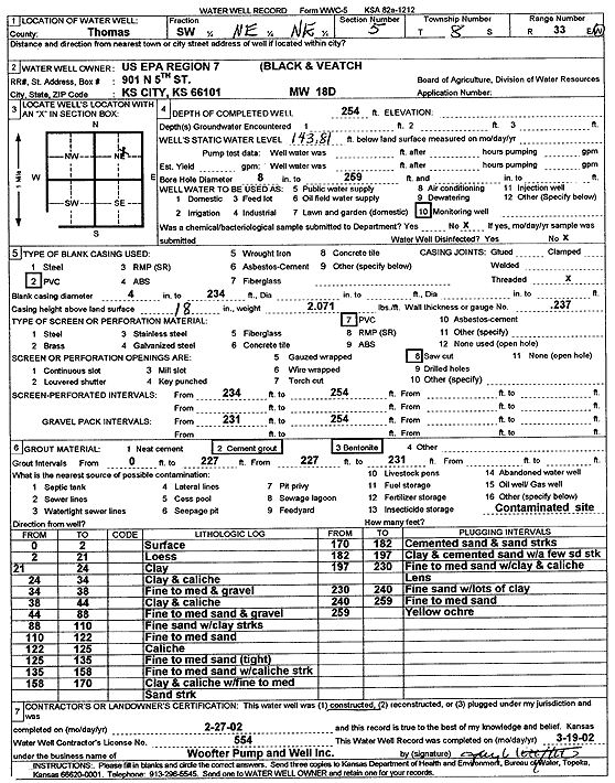
Specific Water Well Detail |
|
|
| Location Info | |||
| Owner: U.S. EPA Region 7, Black and Veatch | Status: Constructed | ||
| Location: T8S, R33W, Sec. 5, SW NE NE | County: Thomas | ||
| Directions: | |||
| Latitude: 39.3915731 | Longitude: -101.0207503 | Datum NAD 27 | |
| Latitude: 39.3915769 | Longitude: -101.0211826 | Datum NAD 83 | |
| Longitude and latitude calculated by Survey from township-range-section-quarter calls. Only good to within the quarter call accuracy. | |||
| View well on interactive map | |||
| General Info | ||
| Well Depth: 254 ft. | Elevation: ft. | |
| Static Water Level: 143.81 ft. | Est. Yield: gpm. | |
| Comp. Date: 27-Feb-2002 | Well Use: Monitoring well/observation/piezometer | |
| DWR Applic. #: | Other ID: MW 18 D | |
| Driller Info | ||
| Driller: Jay C. Woofter Pump & Well, Inc. | License #: 554 | |
| Scanned Form | View scan |
|
Chemical Sample Submitted?:
Water Well disinfected?: | ||
| Casing Info | ||
| Casing Type:
Casing Joints: |
Diam: in. to ft | |
| Casing height above land surface: in
Casing Weight: lbs/ft Wall thickness or gauge no.: | ||
| Screen and Perforation Info | ||
| Screen Type: | Screen Openings: | |
| Screen-perforated intervals | From: ft to ft | |
| Gravel pack intervals | From: ft to ft | |
| Grout Info | ||
| Grout used: | From: to ft | |
| Source of Possible Contamination | ||
| Source: | ||
| Direction from well: | Distance: ft | |
| Lithologic Log
(Log data entered by KGS.) | ||
| From: 0 ft. to 2 ft. | surface | |
| From: 2 ft. to 21 ft. | loess | |
| From: 21 ft. to 24 ft. | clay | |
| From: 24 ft. to 34 ft. | clay and caliche | |
| From: 34 ft. to 38 ft. | fine to medium and gravel | |
| From: 38 ft. to 44 ft. | clay and caliche | |
| From: 44 ft. to 88 ft. | fine to medium sand and gravel | |
| From: 88 ft. to 110 ft. | fine sand with clay streaks | |
| From: 110 ft. to 122 ft. | fine to medium sand | |
| From: 122 ft. to 125 ft. | caliche | |
| From: 125 ft. to 135 ft. | fine to medium sand, tight | |
| From: 135 ft. to 158 ft. | fine to medium sand with caliche streak | |
| From: 158 ft. to 170 ft. | clay and caliche with fine to medium sand streak | |
| From: 170 ft. to 182 ft. | cemented sand and sand streaks | |
| From: 182 ft. to 197 ft. | clay and cemented sand with a few sand streaks | |
| From: 197 ft. to 230 ft. | fine to medium sand with clay and caliche lens | |
| From: 230 ft. to 240 ft. | fine sand with lots of clay | |
| From: 240 ft. to 259 ft. | fine to medium sand | |
| From: 259 ft. to ft. | yellow ochre | |