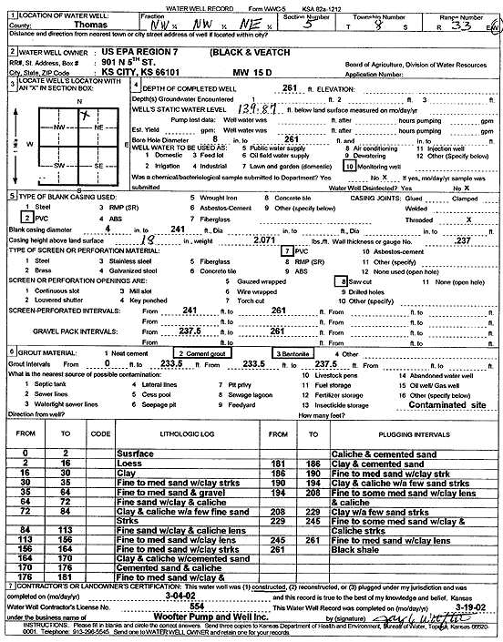
![]() |
![]() |
Specific Water Well Detail |
![]() |
Location Info | |||
Owner: U.S. EPA Region 7, Black and Veatch | Status: Constructed | ||
Location: T8S, R33W, Sec. 5, NW NW NE | County: Thomas | ||
Directions: | |||
Latitude: 39.3933826 | Longitude: -101.0254423 | Datum NAD 27 | |
Latitude: 39.3933864 | Longitude: -101.0258747 | Datum NAD 83 | |
Longitude and latitude calculated by Survey from township-range-section-quarter calls. Only good to within the quarter call accuracy. | |||
View well on interactive map |
General Info | ||
Well Depth: 261 ft. | Elevation: ft. | |
Static Water Level: 139.87 ft. | Est. Yield: gpm. | |
Comp. Date: 04-Mar-2002 | Well Use: Monitoring well/observation/piezometer | |
DWR Applic. #: | Other ID: MW 15 D |
Driller Info | ||
Driller: Jay C. Woofter Pump & Well, Inc. | License #: 554 |
Scanned Form | ||
View form(s) on screen | Download scan(s) | |
The download files contain one or more TIFF images compressed into a ZIP archive. Your browser may be already set up to decompress these files. The TIFFs are 300 dpi archival-quality scans of the WWC5 forms and can be viewed by software like Adobe PhotoShop. |
Chemical Sample Submitted?:
Water Well disinfected?: | ||
Casing Info | ||
Casing Type:
Casing Joints: |
Diam: in. to ft | |
Casing height above land surface: in
Casing Weight: lbs/ft Wall thickness or gauge no.: |
Screen and Perforation Info | ||
Screen Type: | Screen Openings: | |
Screen-perforated intervals | From: ft to ft | |
Gravel pack intervals | From: ft to ft |
Grout Info | ||
Grout used: | From: to ft |
Source of Possible Contamination | ||
Source: | ||
Direction from well: | Distance: ft |
Lithologic Log
(Log data entered by KGS.) | ||
From: 0 ft. to 2 ft. | surface | |
From: 2 ft. to 16 ft. | loess | |
From: 16 ft. to 30 ft. | clay | |
From: 30 ft. to 35 ft. | fine to medium sand with clay streaks | |
From: 35 ft. to 64 ft. | fine to medium sand and gravel | |
From: 64 ft. to 72 ft. | fine sand with clay and caliche | |
From: 72 ft. to 84 ft. | clay and caliche with a few fine sand streaks | |
From: 84 ft. to 113 ft. | fine sand with clay and caliche lens | |
From: 113 ft. to 156 ft. | fine to medium sand with clay lens | |
From: 156 ft. to 164 ft. | fine to medium sand with clay streaks | |
From: 164 ft. to 170 ft. | clay and caliche with cemented sand | |
From: 170 ft. to 176 ft. | cemented sand and caliche | |
From: 176 ft. to 181 ft. | fine to medium sand with clay and caliche and cemented sand | |
From: 181 ft. to 186 ft. | clay and cemented sand | |
From: 186 ft. to 190 ft. | fine to medium sand with clay streak | |
From: 190 ft. to 194 ft. | clay and caliche with a few sand streaks | |
From: 194 ft. to 208 ft. | fine to some medium sand with clay lens and caliche | |
From: 208 ft. to 229 ft. | clay with a few sand streaks | |
From: 229 ft. to 245 ft. | fine to some medium sand with clay and caliche streaks | |
From: 245 ft. to 261 ft. | fine to medium sand with clay lens | |
From: 261 ft. to ft. | black shale |