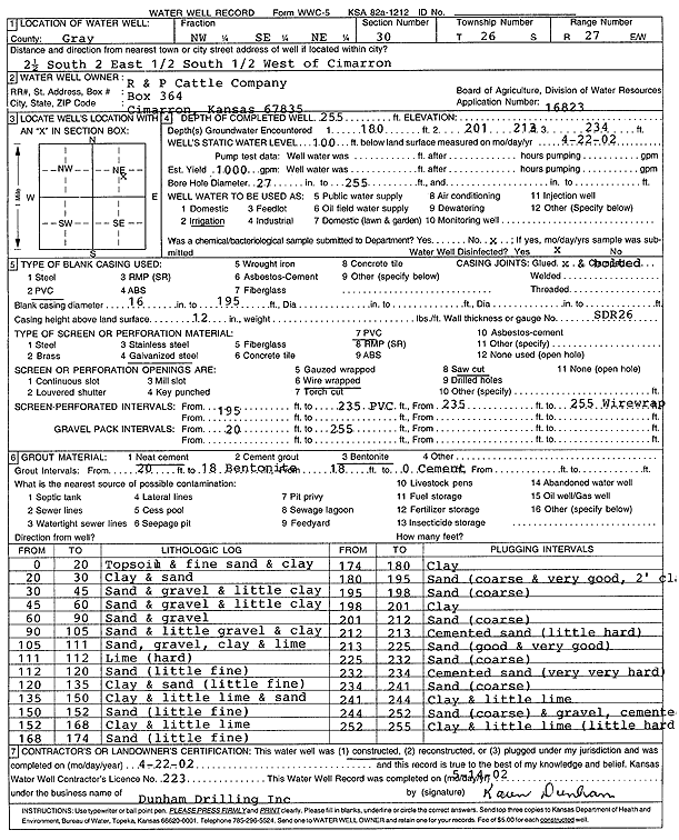
Lithologic Log
(Log data entered by KGS.) |
| |
From: 0 ft. to 20 ft. |
Topsoil and fine sand and clay |
| |
From: 20 ft. to 30 ft. |
Clay and sand |
| |
From: 30 ft. to 45 ft. |
Sand and gravel and little clay |
| |
From: 45 ft. to 60 ft. |
Sand and gravel and little clay |
| |
From: 60 ft. to 90 ft. |
Sand and gravel |
| |
From: 90 ft. to 105 ft. |
Sand and little gravel and clay |
| |
From: 105 ft. to 111 ft. |
Sand, gravel, clay and lime |
| |
From: 111 ft. to 112 ft. |
Lime (hard) |
| |
From: 112 ft. to 120 ft. |
Sand (little fine) |
| |
From: 120 ft. to 135 ft. |
Clay and sand (little fine) |
| |
From: 135 ft. to 150 ft. |
Clay and little lime and sand |
| |
From: 150 ft. to 152 ft. |
Sand (little fine) |
| |
From: 152 ft. to 168 ft. |
Clay and little lime |
| |
From: 168 ft. to 174 ft. |
Sand (little fine) |
| |
From: 174 ft. to 180 ft. |
Clay |
| |
From: 180 ft. to 195 ft. |
Sand (coarse and very good, 2 feet clay |
| |
From: 195 ft. to 198 ft. |
Sand (coarse) |
| |
From: 198 ft. to 201 ft. |
Clay |
| |
From: 201 ft. to 212 ft. |
Sand (coarse) |
| |
From: 212 ft. to 213 ft. |
Cemented sand (little hard) |
| |
From: 213 ft. to 225 ft. |
Sand (good and very good) |
| |
From: 225 ft. to 232 ft. |
Sand (coarse) |
| |
From: 232 ft. to 234 ft. |
Cemented sand (very very hard) |
| |
From: 234 ft. to 241 ft. |
Sand (coarse) |
| |
From: 241 ft. to 244 ft. |
Clay and little lime |
| |
From: 244 ft. to 252 ft. |
Sand (coarse) and gravel, cemented |
| |
From: 252 ft. to 255 ft. |
Clay and little lime (little hard) |