|
|
|
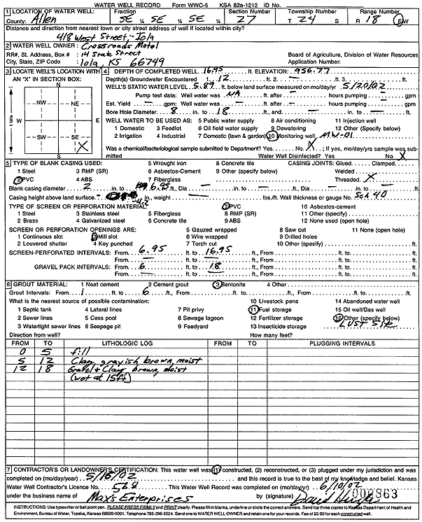
Specific Water Well Detail |
|
|
| Location Info | |||
| Owner: Crossroads Motel | Status: Constructed | ||
| Location: T24S, R18E, Sec. 27, SE SE SE | County: Allen | ||
| Directions: 418 W St, Iola | |||
| Latitude: 37.9231101 | Longitude: -95.4100085 | Datum NAD 27 | |
| Latitude: 37.9231456 | Longitude: -95.4102679 | Datum NAD 83 | |
| Longitude and latitude calculated by Survey from township-range-section-quarter calls. Only good to within the quarter call accuracy. | |||
| View well on interactive map | |||
| General Info | ||
| Well Depth: 16.95 ft. | Elevation: 956.77 ft. | |
| Static Water Level: 5.89 ft. | Est. Yield: gpm. | |
| Comp. Date: 16-May-2002 | Well Use: Monitoring well/observation/piezometer | |
| DWR Applic. #: | Other ID: MW 1 | |
| Driller Info | ||
| Driller: Max's Enterprise | License #: 568 | |
| Scanned Form | View scan |
|
Chemical Sample Submitted?:
Water Well disinfected?: | ||
| Casing Info | ||
| Casing Type:
Casing Joints: |
Diam: in. to ft | |
| Casing height above land surface: in
Casing Weight: lbs/ft Wall thickness or gauge no.: | ||
| Screen and Perforation Info | ||
| Screen Type: | Screen Openings: | |
| Screen-perforated intervals | From: ft to ft | |
| Gravel pack intervals | From: ft to ft | |
| Grout Info | ||
| Grout used: | From: to ft | |
| Source of Possible Contamination | ||
| Source: | ||
| Direction from well: | Distance: ft | |
| Lithologic Log
(Log data entered by KGS.) | ||
| From: 0 ft. to 5 ft. | Fill | |
| From: 5 ft. to 12 ft. | Clay, grayish brown, moist | |
| From: 12 ft. to 18 ft. | Gravel and clay, brown, moist (wet at 15 ft) | |