|
|
|
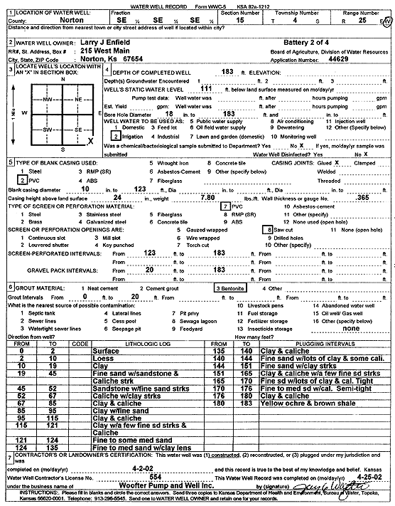
Specific Water Well Detail |
|
|
| Location Info | |||
| Owner: Enfield, Larry J. | Status: Constructed | ||
| Location: T4S, R25W, Sec. 15, SE SE SE | County: Norton | ||
| Directions: (Battery 2 of 4) | |||
| Latitude: 39.6982991 | Longitude: -100.1161492 | Datum NAD 27 | |
| Latitude: 39.6983035 | Longitude: -100.1165594 | Datum NAD 83 | |
| Longitude and latitude calculated by Survey from township-range-section-quarter calls. Only good to within the quarter call accuracy. | |||
| View well on interactive map | |||
| General Info | ||
| Well Depth: 183 ft. | Elevation: ft. | |
| Static Water Level: 111 ft. | Est. Yield: gpm. | |
| Comp. Date: 02-Apr-2002 | Well Use: Irrigation | |
| DWR Applic. #: 44629 | Other ID: | |
| Links | |
| No Wizard information available. | |
| View info from WIMAS Water Right Data base... | |
| Driller Info | ||
| Driller: Jay C. Woofter Pump & Well, Inc. | License #: 554 | |
| Scanned Form | View scan |
|
Chemical Sample Submitted?:
Water Well disinfected?: | ||
| Casing Info | ||
| Casing Type:
Casing Joints: |
Diam: in. to ft | |
| Casing height above land surface: in
Casing Weight: lbs/ft Wall thickness or gauge no.: | ||
| Screen and Perforation Info | ||
| Screen Type: | Screen Openings: | |
| Screen-perforated intervals | From: ft to ft | |
| Gravel pack intervals | From: ft to ft | |
| Grout Info | ||
| Grout used: | From: to ft | |
| Source of Possible Contamination | ||
| Source: | ||
| Direction from well: | Distance: ft | |
| Lithologic Log
(Log data entered by KGS.) | ||
| From: 0 ft. to 2 ft. | surface | |
| From: 2 ft. to 10 ft. | loess | |
| From: 10 ft. to 19 ft. | clay | |
| From: 19 ft. to 45 ft. | fine sand with sandstone and caliche streaks | |
| From: 45 ft. to 52 ft. | sandstone with fine sand streaks | |
| From: 52 ft. to 67 ft. | caliche with clay streaks | |
| From: 67 ft. to 85 ft. | clay and caliche | |
| From: 85 ft. to 95 ft. | clay with fine sand | |
| From: 95 ft. to 115 ft. | clay and caliche | |
| From: 115 ft. to 121 ft. | clay with a few fine sand streaks and caliche | |
| From: 121 ft. to 124 ft. | fine to some medium sand | |
| From: 124 ft. to 135 ft. | fine to medium sand with clay lens | |
| From: 135 ft. to 140 ft. | clay and caliche | |
| From: 140 ft. to 144 ft. | fine sand with lots of clay and some caliche | |
| From: 144 ft. to 151 ft. | fine sand with clay streaks | |
| From: 151 ft. to 165 ft. | clay and caliche with a few fine sand streaks | |
| From: 165 ft. to 170 ft. | fine sand with lots of clay and caliche, tight | |
| From: 170 ft. to 176 ft. | fine to medium sand with caliche, semi-tight | |
| From: 176 ft. to 180 ft. | clay and caliche | |
| From: 180 ft. to 183 ft. | yellow ochre and brown shale | |