|
|
|
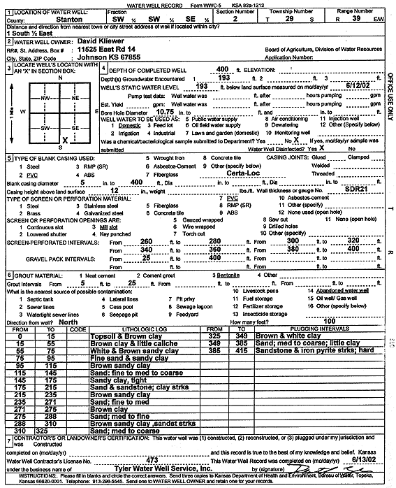
Specific Water Well Detail |
|
|
| Location Info | |||
| Owner: Kliewer, David | Status: Constructed | ||
| Location: T29S, R39W, Sec. 2, SW SW SE | County: Stanton | ||
| Directions: from Johnson, 1 mi S and 0.5 mi E | |||
| Latitude: 37.5486088 | Longitude: -101.5520282 | Datum NAD 27 | |
| Latitude: 37.548628 | Longitude: -101.552475 | Datum NAD 83 | |
| Longitude and latitude calculated by Survey from township-range-section-quarter calls. Only good to within the quarter call accuracy. | |||
| View well on interactive map | |||
| General Info | ||
| Well Depth: 400 ft. | Elevation: ft. | |
| Static Water Level: 193 ft. | Est. Yield: gpm. | |
| Comp. Date: 13-Jun-2002 | Well Use: Domestic | |
| DWR Applic. #: | Other ID: | |
| Driller Info | ||
| Driller: Destal Tyler Water Well Service | License #: 473 | |
| Scanned Form | View scan |
|
Chemical Sample Submitted?:
Water Well disinfected?: | ||
| Casing Info | ||
| Casing Type:
Casing Joints: |
Diam: in. to ft | |
| Casing height above land surface: in
Casing Weight: lbs/ft Wall thickness or gauge no.: | ||
| Screen and Perforation Info | ||
| Screen Type: | Screen Openings: | |
| Screen-perforated intervals | From: ft to ft | |
| Gravel pack intervals | From: ft to ft | |
| Grout Info | ||
| Grout used: | From: to ft | |
| Source of Possible Contamination | ||
| Source: | ||
| Direction from well: | Distance: ft | |
| Lithologic Log
(Log data entered by KGS.) | ||
| From: 0 ft. to 15 ft. | topsoil and brown clay | |
| From: 15 ft. to 55 ft. | brown clay and little caliche | |
| From: 55 ft. to 75 ft. | white and brown sandy clay | |
| From: 75 ft. to 95 ft. | fine sand and sandy clay | |
| From: 95 ft. to 115 ft. | brown sandy clay | |
| From: 115 ft. to 145 ft. | sand; fine to med to coarse | |
| From: 145 ft. to 175 ft. | sandy clay, tight | |
| From: 175 ft. to 215 ft. | sand and sandstone; clay streaks | |
| From: 215 ft. to 235 ft. | brown sandy clay | |
| From: 235 ft. to 271 ft. | sand; fine to med | |
| From: 271 ft. to 275 ft. | brown clay | |
| From: 275 ft. to 288 ft. | sand; med to fine | |
| From: 288 ft. to 310 ft. | brown sand clay, sandstone streaks | |
| From: 310 ft. to 325 ft. | sand; med to coarse | |
| From: 325 ft. to 349 ft. | brown and white clay | |
| From: 349 ft. to 385 ft. | sand; med to coarse; little clay | |
| From: 385 ft. to 415 ft. | sandstone and iron pyrite streaks; hard | |