|
|
|
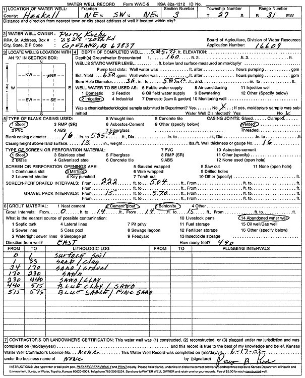
Specific Water Well Detail |
|
|
| Location Info | |||
| Owner: Kocha, Perry | Status: Constructed | ||
| Location: T27S, R31W, Sec. 3, NE SW NE | County: Haskell | ||
| Directions: | |||
| Latitude: 37.7317631 | Longitude: -100.693969 | Datum NAD 27 | |
| Latitude: 37.7317869 | Longitude: -100.6944042 | Datum NAD 83 | |
| Longitude and latitude calculated by Survey from township-range-section-quarter calls. Only good to within the quarter call accuracy. | |||
| View well on interactive map | |||
| General Info | ||
| Well Depth: 585.8 ft. | Elevation: ft. | |
| Static Water Level: ft. | Est. Yield: 650 gpm. | |
| Comp. Date: 01-Jun-2002 | Well Use: Irrigation | |
| DWR Applic. #: 16609 | Other ID: | |
| Links | |
| No Wizard information available. | |
| View info from WIMAS Water Right Data base... | |
| Driller Info | ||
| Driller: well owner | License #: | |
| Scanned Form | View scan |
|
Chemical Sample Submitted?:
Water Well disinfected?: | ||
| Casing Info | ||
| Casing Type:
Casing Joints: |
Diam: in. to ft | |
| Casing height above land surface: in
Casing Weight: lbs/ft Wall thickness or gauge no.: | ||
| Screen and Perforation Info | ||
| Screen Type: | Screen Openings: | |
| Screen-perforated intervals | From: ft to ft | |
| Gravel pack intervals | From: ft to ft | |
| Grout Info | ||
| Grout used: | From: to ft | |
| Source of Possible Contamination | ||
| Source: | ||
| Direction from well: | Distance: ft | |
| Lithologic Log
(Log data entered by KGS.) | ||
| From: 0 ft. to 1 ft. | surface soil | |
| From: 1 ft. to 33 ft. | sand/clay | |
| From: 34 ft. to 170 ft. | sand/gravel | |
| From: 170 ft. to 230 ft. | sand | |
| From: 230 ft. to 440 ft. | sand/clay | |
| From: 440 ft. to 515 ft. | blue clay/sand | |
| From: 515 ft. to 575 ft. | blue shale/fine sand | |