|
|
|
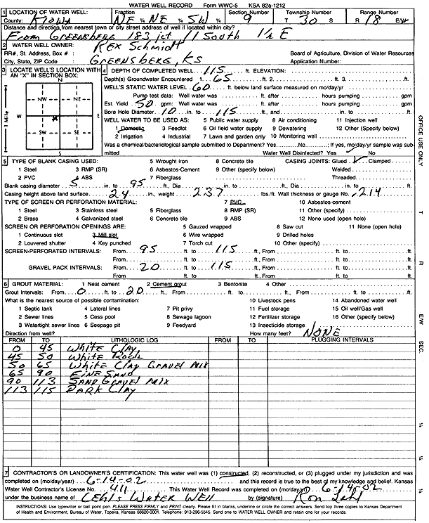
Specific Water Well Detail |
|
|
| Location Info | |||
| Owner: Schmidt, Rex | Status: Constructed | ||
| Location: T30S, R18W, Sec. 9, NE NE SW | County: Kiowa | ||
| Directions: from 183 junction, Greensberg: 11 mi S, 1.5 mi E | |||
| Latitude: 37.44664 | Longitude: -99.2936663 | Datum NAD 27 | |
| Latitude: 37.4466608 | Longitude: -99.2940571 | Datum NAD 83 | |
| Longitude and latitude calculated by Survey from township-range-section-quarter calls. Only good to within the quarter call accuracy. | |||
| View well on interactive map | |||
| General Info | ||
| Well Depth: 115 ft. | Elevation: ft. | |
| Static Water Level: 60 ft. | Est. Yield: 50 gpm. | |
| Comp. Date: 14-Jun-2002 | Well Use: Domestic | |
| DWR Applic. #: | Other ID: | |
| Driller Info | ||
| Driller: Lehl's Water Well Service | License #: 411 | |
| Scanned Form | View scan |
|
Chemical Sample Submitted?:
Water Well disinfected?: | ||
| Casing Info | ||
| Casing Type:
Casing Joints: |
Diam: in. to ft | |
| Casing height above land surface: in
Casing Weight: lbs/ft Wall thickness or gauge no.: | ||
| Screen and Perforation Info | ||
| Screen Type: | Screen Openings: | |
| Screen-perforated intervals | From: ft to ft | |
| Gravel pack intervals | From: ft to ft | |
| Grout Info | ||
| Grout used: | From: to ft | |
| Source of Possible Contamination | ||
| Source: | ||
| Direction from well: | Distance: ft | |
| Lithologic Log
(Log data entered by KGS.) | ||
| From: 0 ft. to 45 ft. | white clay | |
| From: 45 ft. to 50 ft. | white rock | |
| From: 50 ft. to 65 ft. | white clay and gravel mix | |
| From: 65 ft. to 90 ft. | fine sand | |
| From: 90 ft. to 113 ft. | sand and gravel mix | |
| From: 113 ft. to 115 ft. | dark clay | |