|
|
|
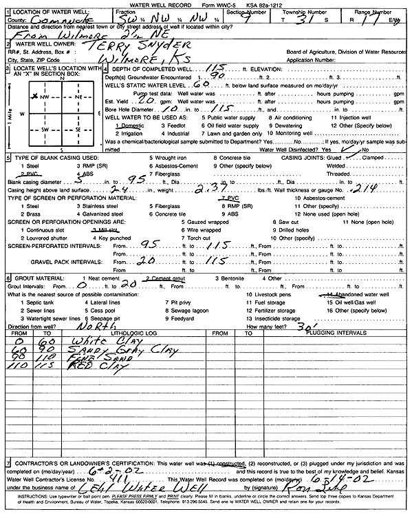
Specific Water Well Detail |
|
|
| Location Info | |||
| Owner: Snyder, Terry | Status: Constructed | ||
| Location: T31S, R17W, Sec. 9, SW NW NW | County: Comanche | ||
| Directions: from Wilmore: 2.5 mi NE | |||
| Latitude: 37.3661944 | Longitude: -99.1818838 | Datum NAD 27 | |
| Latitude: 37.3662167 | Longitude: -99.1822711 | Datum NAD 83 | |
| Longitude and latitude calculated by Survey from township-range-section-quarter calls. Only good to within the quarter call accuracy. | |||
| View well on interactive map | |||
| General Info | ||
| Well Depth: 115 ft. | Elevation: ft. | |
| Static Water Level: 60 ft. | Est. Yield: 20 gpm. | |
| Comp. Date: 02-Jun-2002 | Well Use: Domestic | |
| DWR Applic. #: | Other ID: | |
| Driller Info | ||
| Driller: Ronald Lehl's Water Well Service | License #: 411 | |
| Scanned Form | View scan |
|
Chemical Sample Submitted?:
Water Well disinfected?: | ||
| Casing Info | ||
| Casing Type:
Casing Joints: |
Diam: in. to ft | |
| Casing height above land surface: in
Casing Weight: lbs/ft Wall thickness or gauge no.: | ||
| Screen and Perforation Info | ||
| Screen Type: | Screen Openings: | |
| Screen-perforated intervals | From: ft to ft | |
| Gravel pack intervals | From: ft to ft | |
| Grout Info | ||
| Grout used: | From: to ft | |
| Source of Possible Contamination | ||
| Source: | ||
| Direction from well: | Distance: ft | |
| Lithologic Log
(Log data entered by KGS.) | ||
| From: 0 ft. to 60 ft. | white clay | |
| From: 60 ft. to 90 ft. | sandy gray clay | |
| From: 90 ft. to 110 ft. | fine sand | |
| From: 110 ft. to 115 ft. | red clay | |