|
|
|
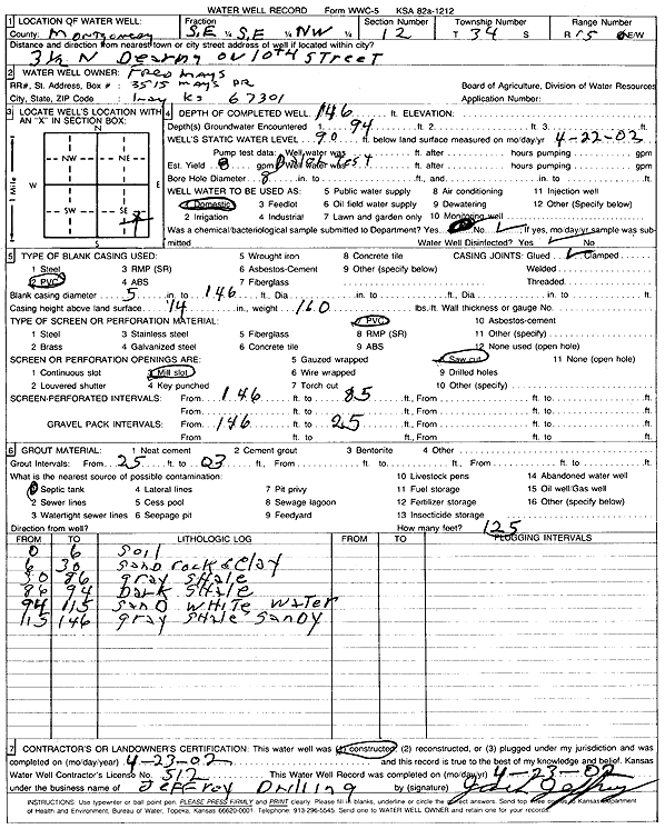
Specific Water Well Detail |
|
|
| Location Info | |||
| Owner: Mays, Fred | Status: Constructed | ||
| Location: T34S, R15E, Sec. 12, SE SE NW | County: Montgomery | ||
| Directions: from Dearing: 3.5 mi N on 10th St | |||
| Latitude: 37.1031144 | Longitude: -95.7206062 | Datum NAD 27 | |
| Latitude: 37.1031894 | Longitude: -95.720863 | Datum NAD 83 | |
| Longitude and latitude calculated by Survey from township-range-section-quarter calls. Only good to within the quarter call accuracy. | |||
| View well on interactive map | |||
| General Info | ||
| Well Depth: 146 ft. | Elevation: ft. | |
| Static Water Level: 90 ft. | Est. Yield: 8 gpm. | |
| Comp. Date: 23-Apr-2002 | Well Use: Domestic | |
| DWR Applic. #: | Other ID: | |
| Driller Info | ||
| Driller: Jeffrey Well Drilling | License #: 512 | |
| Scanned Form | View scan |
|
Chemical Sample Submitted?:
Water Well disinfected?: | ||
| Casing Info | ||
| Casing Type:
Casing Joints: |
Diam: in. to ft | |
| Casing height above land surface: in
Casing Weight: lbs/ft Wall thickness or gauge no.: | ||
| Screen and Perforation Info | ||
| Screen Type: | Screen Openings: | |
| Screen-perforated intervals | From: ft to ft | |
| Gravel pack intervals | From: ft to ft | |
| Grout Info | ||
| Grout used: | From: to ft | |
| Source of Possible Contamination | ||
| Source: | ||
| Direction from well: | Distance: ft | |
| Lithologic Log
(Log data entered by KGS.) | ||
| From: 0 ft. to 6 ft. | soil | |
| From: 6 ft. to 30 ft. | sand rock and clay | |
| From: 30 ft. to 86 ft. | gray shale | |
| From: 86 ft. to 94 ft. | dark shale | |
| From: 94 ft. to 115 ft. | sand, white | |
| From: 115 ft. to 146 ft. | gray sandy shale | |